Alamo Plaza Historic District
Also known as: See Also:Alamo, The

Why it's listed
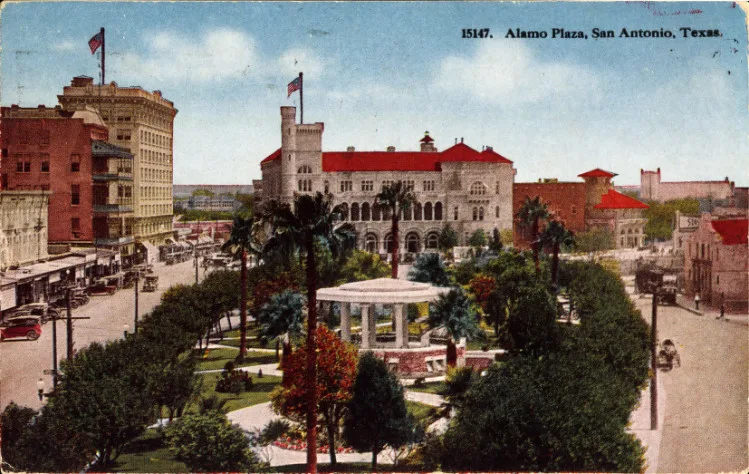
Alamo Plaza Historic District covers the commercial heart of downtown San Antonio around the Alamo chapel. The plaza was once the courtyard of Mission San Antonio de Valero, founded in 1724. After the 1836 battle, squatters and later the army used the ruins. The city created the present open space in 1871 by acquiring the old granary and merging the courtyard with the Plaza de Valero. Most surrounding buildings date from the late 19th century, when leading firms opened stores here. They include the Menger Hotel, the Crockett Block, the Reuter and Moore buildings, the Turn Verein of 1891, the 1937 Post Office and the 1926 Medical Arts Building. A 1940 Cenotaph honors the Alamo defenders. Many Victorian facades were covered by mid-20th century plaster and alterations, yet the district keeps a uniform scale of one to four stories on most sides. Its listing recognizes the setting around the shrine and the potential to restore the historic streetscape.
Significance in brief: The district grew up around the Alamo, Texas' most famous shrine, and has long been a focal point of the city. Its late 19th and early 20th century commercial buildings, several by architects such as Alfred Giles, James Wahrenberger and Ralph Cameron, keep a consistent scale. Many Victorian facades are hidden under later plaster but could be restored.
Machine-generated summary. This summary was generated by a language model from the official nomination document and has not been reviewed line by line by an editor. It may contain errors. Check the source document before relying on any detail. Source: nomination document (PDF) · National Archives catalog entry. NRHP reference 77001425, listed July 13, 1977. Summary generated October 2026 (model claude-sonnet-5-5, prompt v1.0-2026-10-29, confidence medium).
Key facts
| Address | Roughly bounded by S. Broadway, Commerce, Bonham and Travis Sts., San Antonio |
|---|---|
| County | Bexar County |
| Listed | July 13, 1977 |
| Reference number | 77001425 |
| Resource type | District |
| Architect / builder | Alfred Giles; James Wahrenberger; Ralph Cameron; John Fries; Padgett; J. Riely Gordon; Adams and Adams (Cenotaph); Pompeo Coppini (sculptor) |
| Architectural style | Mixed commercial styles: Victorian-Italianate, Renaissance Revival, Chateauesque, Commercial Style |
| Areas of significance | Community Planning and Development, Commerce, Military, Transportation, Architecture, Religion |
| Level of significance | National |
| Status (as stated in the nomination) | Condition listed as excellent, good and fair; the district is both occupied and unoccupied. Many facades are altered, some large buildings had trouble renting office space, and two buildings were threatened with demolition. Plaza improvements were in progress. |
| Acreage | 30 |
| Coordinates | 29.42541, -98.48592 (NPS GIS) |
What listing means for this property
This is a historic district. Buildings within its boundary are either contributing (they add to the district's significance) or non-contributing. Owners of contributing income-producing buildings can claim the 20% federal rehabilitation tax credit; homeowners should look at state credits. National Register districts impose no design review by themselves; a local historic district ordinance, if one exists, does (the difference explained).
General information, not legal or tax advice. Rules change; confirm with your State Historic Preservation Office or a qualified adviser.
Sources and further reading
- National Park Service, National Register of Historic Places database (snapshot May 2026), reference 77001425.
- Nomination form (PDF, National Archives) — catalog entry
- Wikipedia article (used for cross-checking only; text not reproduced here)
- Wikidata Q4705973
- This listing as JSON
Last updated October 2026. Found an error? See the editorial policy for how to report it.