Chestnut Hill Historic District
Also known as: See Also:82003806; 78002445; 79002318; 72001151; 7700184; Thomas

Why it's listed
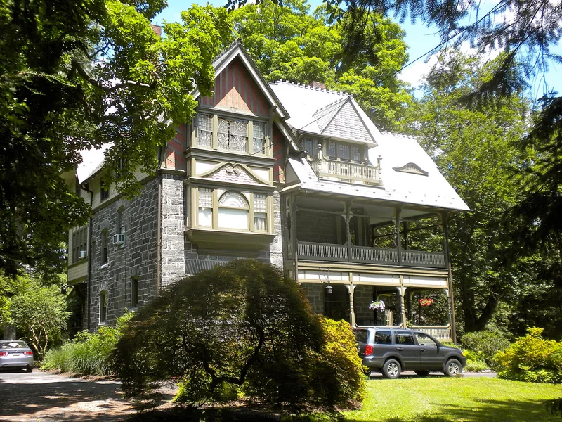
Chestnut Hill is a residential neighborhood in northwest Philadelphia with more than 2,600 buildings, most of them single-family houses of two or three stories. Settlement began in the early 1700s along Germantown Pike and Bethlehem Pike, and the arrival of the Philadelphia, Germantown and Norristown Railroad in 1854 turned the village into a summer retreat. Later, the Pennsylvania Railroad extension in 1884 prompted Henry Howard Houston's planned western section, and Dr. George Woodward's work from 1904 added courtyard housing and landscaped streets. Local Wissahickon schist stone is the common material throughout, and many houses are set into the land along the Wissahickon and Cresheim valleys. The district is listed for its architecture, its wide range of styles by leading Philadelphia architects, and its planning, which followed the natural contours of the land. Much of the surrounding valley was later preserved as parkland.
Significance in brief: The nomination argues that the district is an uncommon assemblage of most residential styles found in the Philadelphia region, with work by nearly every major Philadelphia architect or firm. Its buildings are unified by human scale, the pervasive use of local Wissahickon schist stone, and landscaping tied to the Wissahickon Valley. Its community planning followed the natural land contours, shaped significantly by Henry Howard Houston and Dr. George Woodward.
Machine-generated summary. This summary was generated by a language model from the official nomination document and has not been reviewed line by line by an editor. It may contain errors. Check the source document before relying on any detail. Source: nomination document (PDF) · National Archives catalog entry. NRHP reference 85001334, listed June 20, 1985. Summary generated October 2026 (model claude-haiku-5-5, prompt v1.1-2026-10-29, confidence medium).
Key facts
| Address | Roughly bounded by Fairmount Park and Montgomery Co. Line, Philadelphia |
|---|---|
| County | Philadelphia |
| Listed | June 20, 1985 |
| Reference number | 85001334 |
| Resource type | District |
| Period of significance | 1700-1935 |
| Areas of significance | Community Planning and Development, Landscape Architecture, Commerce, Architecture, Social History |
| Level of significance | National |
| Acreage | 1920 |
| Within district | Fairmount Park |
| Coordinates | 40.06349, -75.20949 (NPS GIS) |
What listing means for this property
This is a historic district. Buildings within its boundary are either contributing (they add to the district's significance) or non-contributing. Owners of contributing income-producing buildings can claim the 20% federal rehabilitation tax credit; homeowners should look at state credits. National Register districts impose no design review by themselves; a local historic district ordinance, if one exists, does (the difference explained).
General information, not legal or tax advice. Rules change; confirm with your State Historic Preservation Office or a qualified adviser.
Sources and further reading
- National Park Service, National Register of Historic Places database (snapshot May 2026), reference 85001334.
- Nomination form (PDF, National Archives) — catalog entry
- Wikipedia article (used for cross-checking only; text not reproduced here)
- Wikidata Q5093951
- This listing as JSON
Last updated October 2026. Found an error? See the editorial policy for how to report it.