Old Burying Ground
Also known as: See Also:Beaufort Historic District

Why it's listed
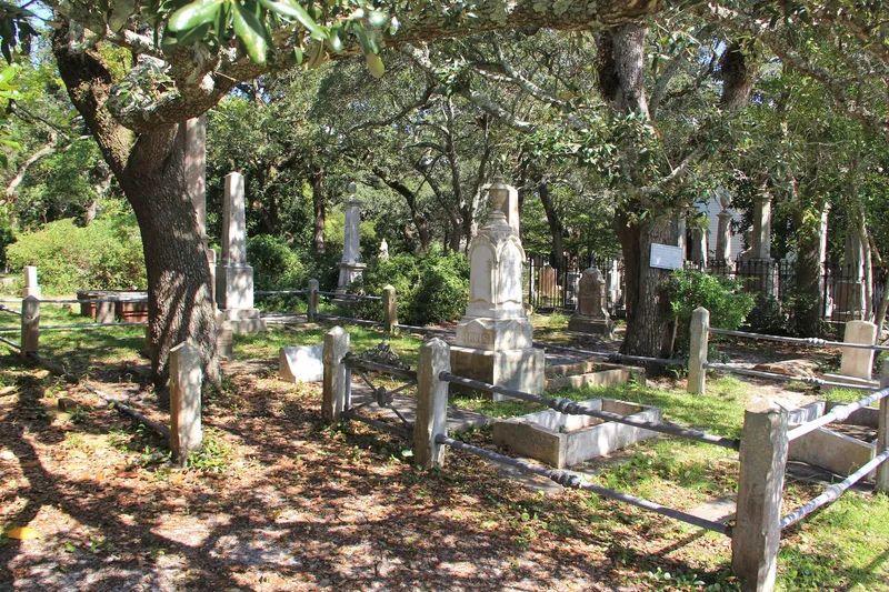
Beaufort's Old Burying Ground fills most of a block between Ann, Craven and Broad streets and covers about two acres. A 1724 deed to the Anglican parish is the earliest definite record of its use for burial, and it was enlarged in 1731 and again by Methodist and Baptist church lots in the nineteenth century. A concrete wall surrounds it, and live oaks draped with resurrection ferns shade the ground. The markers include cypress slabs, long brick grave covers, obelisks and ornate iron-fenced family plots, among them the Norwood plot's 1865 fence from Boston. Many stones are signed by makers in Boston, Charleston, Brooklyn and Baltimore, reflecting Beaufort's ties to the sea. Buried here are Otway Burns, whose grave is marked by a cannon from his privateer, and Captain Josiah Pender. Together, the history, the varied markers and the shaded setting led to its listing.
Significance in brief: The nomination points to the cemetery's long use from the early eighteenth century, its notable burials, and its wide range of grave markers, including cypress slabs, brick grave covers and signed stones from coastal cities. It also cites the landscape setting of old trees and lichen-covered stones.
Machine-generated summary. This summary was generated by a language model from the official nomination document and has not been reviewed line by line by an editor. It may contain errors. Check the source document before relying on any detail. Source: nomination document (PDF) · National Archives catalog entry. NRHP reference 74001332, listed April 8, 1974. Summary generated October 2026 (model claude-sonnet-5-5, prompt v1.0-2026-10-29, confidence medium).
Key facts
| Address | Bounded by Ann, Craven, and Broad Sts., Beaufort |
|---|---|
| County | Carteret County |
| Listed | April 8, 1974 |
| Reference number | 74001332 |
| Resource type | Site |
| Period of significance | 18th and 19th centuries |
| Areas of significance | Landscape Architecture, Art, Religion |
| Level of significance | Local |
| Status (as stated in the nomination) | Described as deteriorated but unaltered, on its original site, with preservation work in progress; in use as a cemetery. |
| Acreage | 2 |
| Within district | Beaufort Historic District |
| Coordinates | 34.71875, -76.66374 (NPS GIS) |
What listing means for this property
Sites (archaeological sites, battlefields, landscapes) are often listed with a restricted address to protect them from looting or disturbance. Listing is honorary for private owners; federal undertakings on or near the site go through Section 106 review, and state laws may protect burials and artefacts regardless of listing.
General information, not legal or tax advice. Rules change; confirm with your State Historic Preservation Office or a qualified adviser.
Sources and further reading
- National Park Service, National Register of Historic Places database (snapshot May 2026), reference 74001332.
- Nomination form (PDF, National Archives) — catalog entry
- Wikipedia article (used for cross-checking only; text not reproduced here)
- Wikidata Q18151877
- This listing as JSON
Last updated October 2026. Found an error? See the editorial policy for how to report it.