Beaufort Historic District
Also known as: See Also:Gibbs House; Old Burying Ground; Henry,Jacob, House

Why it's listed
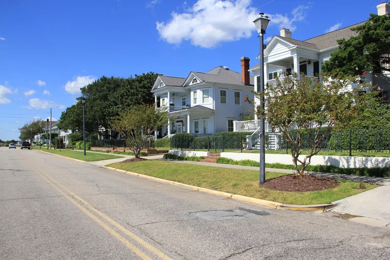
Beaufort is a small coastal town in Carteret County, North Carolina, laid out in a compact grid beside a harbor opposite Beaufort Inlet. Settled in the early eighteenth century and surveyed by Richard Graves, it became a port of entry in 1722 and was incorporated in 1723. Its livelihood has long depended on fishing, shipbuilding, shipping, resort trade and marine research. The district covers about 900 acres of mostly one- and two-story frame houses, many with the steep-then-shallow gable roofs and full-width double porches that give the town its look. Front Street faces the water with a row of white houses, from coastal double-porch dwellings to Queen Anne cottages. Other features include St. Paul's Episcopal Church (1857), the 1907 Carteret County Courthouse, a late nineteenth and early twentieth century commercial row, and the Old Burying Ground dating from about 1724. Few buildings are exceptional on their own, but the consistent scale and form of the whole town is the basis for its listing.
Significance in brief: The nomination argues that Beaufort is a rare, little-altered maritime village whose plan, scale and consistent architecture reflect its dependence on the sea. Its multi-slope gable roofs, double porches, chimneys and mantels form a distinctive local building tradition. The waterfront row of houses, the commercial block, the churches and the Old Burying Ground add to its character.
Machine-generated summary. This summary was generated by a language model from the official nomination document and has not been reviewed line by line by an editor. It may contain errors. Check the source document before relying on any detail. Source: nomination document (PDF) · National Archives catalog entry. NRHP reference 74001331, listed May 6, 1974. Summary generated October 2026 (model claude-sonnet-5-5, prompt v1.0-2026-10-29, confidence medium).
Key facts
| Address | Roughly bounded by Beaufort Channel, Pine and Fulford Sts., and Taylors Creek, Beaufort |
|---|---|
| County | Carteret County |
| Listed | May 6, 1974 |
| Reference number | 74001331 |
| Resource type | District |
| Period of significance | Ca. 1710 to present |
| Architect / builder | Herbert Woodley Simpson (designer of the 1907 Carteret County Courthouse); Richard Graves (original town survey) |
| Architectural style | Vernacular coastal types with Georgian, Federal, Greek Revival, Gothic Revival, Queen Anne and Shingle influences |
| Areas of significance | Community Planning and Development, Commerce, Military, Transportation, Science, Architecture |
| Level of significance | National |
| Status (as stated in the nomination) | Condition is marked as mixed on the form, from excellent to deteriorated. Urban renewal is noted as a threat to the commercial block. |
| Acreage | 900 |
| Coordinates | 34.71305, -76.66846 (NPS GIS) |
What listing means for this property
This is a historic district. Buildings within its boundary are either contributing (they add to the district's significance) or non-contributing. Owners of contributing income-producing buildings can claim the 20% federal rehabilitation tax credit; homeowners should look at state credits. National Register districts impose no design review by themselves; a local historic district ordinance, if one exists, does (the difference explained).
General information, not legal or tax advice. Rules change; confirm with your State Historic Preservation Office or a qualified adviser.
Sources and further reading
- National Park Service, National Register of Historic Places database (snapshot May 2026), reference 74001331.
- Nomination form (PDF, National Archives) — catalog entry
- Wikipedia article (used for cross-checking only; text not reproduced here)
- Wikidata Q18148381
- This listing as JSON
Last updated October 2026. Found an error? See the editorial policy for how to report it.