Fort Monroe (Boundary Increase & Additional Documentation)
Also known as: Vdhr # 114-0002

Why it's listed
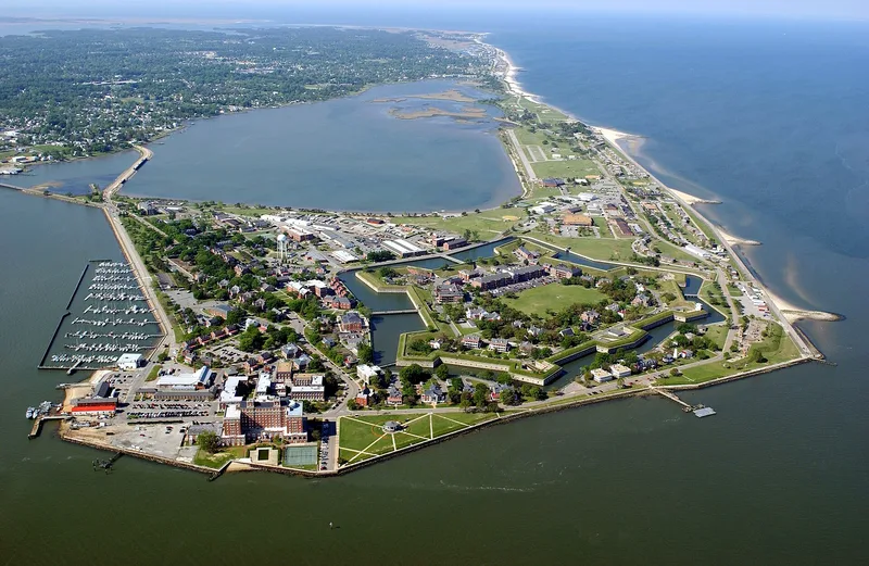
Fort Monroe is a seven-sided stone fortress on Old Point Comfort in Hampton, Virginia, built between 1819 and 1847 to a design by Simon Bernard, a former aide to Napoleon I. It covers sixty-three acres, and the nominated area includes all land within the sea wall, including the 1802 Old Point Comfort Lighthouse, Engineer Wharf, officers' quarters and detached Endicott-era gun batteries. The fort was meant to protect the channel from Chesapeake Bay into Hampton Roads and became the keystone of a chain of coastal forts. It stayed in Union hands throughout the Civil War and became a refuge for escaped slaves after 1861. Jefferson Davis was held in one of its casemates after the war. Robert E. Lee served here as a young engineer, and Edgar Allan Poe served as a private. The Army's first artillery school was founded here in 1824 and remained, with interruptions, until 1946. The batteries show the coast artillery era.
Significance in brief: The form calls it the largest fortress ever built in America, tied to figures such as Robert E. Lee, Edgar Allan Poe, Abraham Lincoln and Jefferson Davis. It was a haven for escaped slaves in the Civil War and home to the Army's first artillery school. Its remaining batteries show the development of coast artillery from 1824 to 1904.
Machine-generated summary. This summary was generated by a language model from the official nomination document and has not been reviewed line by line by an editor. It may contain errors. Check the source document before relying on any detail. Source: nomination document (PDF). NRHP reference 13000708, listed March 9, 2015. Summary generated October 2026 (model claude-sonnet-5-5, prompt v1.0-2026-10-29, confidence medium).
Key facts
| Address | Address restricted by the NPS (common for archaeological sites and some private homes) |
|---|---|
| County | Hampton |
| Listed | March 9, 2015 |
| Reference number | 13000708 |
| Resource type | District |
| Period of significance | 1819-1946 |
| Architect / builder | Simon Bernard (designer, former aide to Napoleon I) |
| Architectural style | Seven-sided bastioned fortress after the Vauban plan; Endicott-era batteries |
| Areas of significance | Military, Engineering, Black, Architecture, Historic - Non-Aboriginal, Historic - Aboriginal |
| Level of significance | National |
| Status (as stated in the nomination) | Listed as publicly owned (Department of the Army) and occupied, with a dense mix of historic and contemporary structures; Battery Anderson/George Ruggles is described as crumbling. |
| Acreage | 165 |
| Coordinates | 37.00361, -76.30750 (Wikidata) |
What listing means for this property
This is a historic district. Buildings within its boundary are either contributing (they add to the district's significance) or non-contributing. Owners of contributing income-producing buildings can claim the 20% federal rehabilitation tax credit; homeowners should look at state credits. National Register districts impose no design review by themselves; a local historic district ordinance, if one exists, does (the difference explained).
General information, not legal or tax advice. Rules change; confirm with your State Historic Preservation Office or a qualified adviser.
Sources and further reading
- National Park Service, National Register of Historic Places database (snapshot May 2026), reference 13000708.
- Nomination form (PDF, National Archives)
- Wikipedia article (used for cross-checking only; text not reproduced here)
- Wikidata Q1438639
- This listing as JSON
Last updated October 2026. Found an error? See the editorial policy for how to report it.