Phoebus Historic District
Also known as: Mill Creek; Chesapeake City; Vdhr# 114-5002
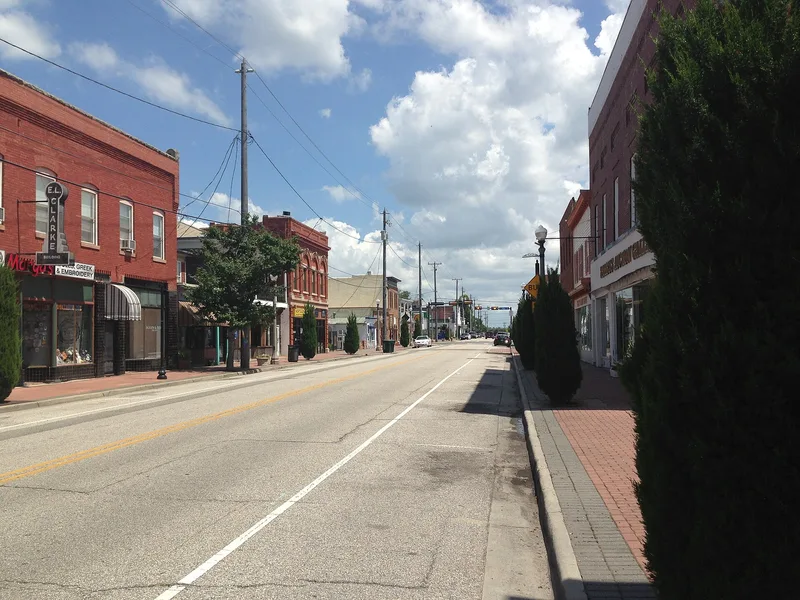

Why it's listed
Phoebus is a historic town district in Hampton, Virginia, beside Mill Creek and close to Old Point Comfort and Fort Monroe. The settlement began in the seventeenth century, was laid out on a gridiron street plan in 1874 as Chesapeake City, and took the name Phoebus in 1900. A railroad spur built through town in the early 1880s drove growth, and most surviving buildings date from that era onward. Hampton annexed the town in 1952. The Hampton Roads Bridge Tunnel opened in 1957 and bypassed the community, ending ferry and rail traffic and slowing new construction for decades. As a result, the district keeps its original plan and a wide range of modest commercial, civic, religious and residential buildings, including Queen Anne houses, Bungalows, Colonial Revival dwellings and Art Deco storefronts. It was recognized for its architecture and its community planning and development between 1874 and 1957.
Significance in brief: The nomination argues the district retains its original plan and many buildings from its heyday as an independent railroad-era town, which supports significance in architecture and community planning and development. The opening of the Hampton Roads Bridge Tunnel in 1957 bypassed the town and slowed later change, leaving it architecturally little altered. Criteria A and C are marked.
Machine-generated summary. This summary was generated by a language model from the official nomination document and has not been reviewed line by line by an editor. It may contain errors. Check the source document before relying on any detail. Source: nomination document (PDF) · National Archives catalog entry. NRHP reference 06001098, listed December 1, 2006. Summary generated October 2026 (model claude-sonnet-5-5, prompt v1.0-2026-10-29, confidence medium).
Key facts
| Address | Roughly bounded by VA 64, Mallory St., E. County St. and Willard Ave., Hampton (Independent City) |
|---|---|
| County | Hampton |
| Listed | December 1, 2006 |
| Reference number | 06001098 |
| Resource type | District |
| Period of significance | 1874-1957 |
| Architect / builder | Holtzclaw, Charles Taylor; Wenderoth, Oscar; other architects listed on a continuation sheet |
| Architectural style | Late Victorian (Italianate, Queen Anne, Romanesque); Late 19th and 20th Century Revivals (Beaux Arts, Colonial Revival, Classical Revival, Late Gothic Revival); Commercial Style, Bungalow/Craftsman; Modern Movement (Art Deco) |
| Criteria |
|
| Areas of significance | Architecture, Community Planning and Development |
| Level of significance | Local |
| Status (as stated in the nomination) | Described as a small section of Hampton with a commercial corridor and residential neighborhood showing early signs of revitalization; most buildings remain in use as homes, shops and civic buildings. |
| Acreage | 86 |
| Coordinates | 37.01845, -76.32052 (NPS GIS) |
What listing means for this property
This is a historic district. Buildings within its boundary are either contributing (they add to the district's significance) or non-contributing. Owners of contributing income-producing buildings can claim the 20% federal rehabilitation tax credit; homeowners should look at state credits. National Register districts impose no design review by themselves; a local historic district ordinance, if one exists, does (the difference explained).
General information, not legal or tax advice. Rules change; confirm with your State Historic Preservation Office or a qualified adviser.
Sources and further reading
- National Park Service, National Register of Historic Places database (snapshot May 2026), reference 06001098.
- Nomination form (PDF, National Archives) — catalog entry
- Wikipedia article (used for cross-checking only; text not reproduced here)
- Wikidata Q845732
- This listing as JSON
Last updated October 2026. Found an error? See the editorial policy for how to report it.