Society Hill Historic District
Also known as: Washington Square East Redevelopment Area; See Also:71000723
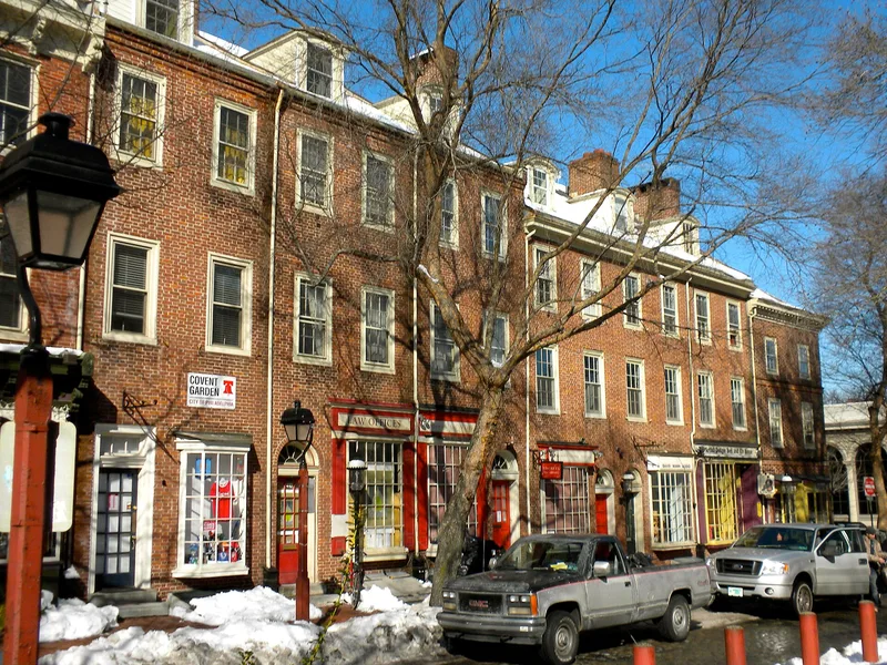

Why it's listed
Society Hill is the oldest part of Philadelphia, laid out in 1682 by surveyor Thomas Holme for William Penn. The name comes from the Free Society of Traders, which bought 20,000 acres from Penn. The district covers about 150 acres and contains more than 575 certified eighteenth and nineteenth century commercial, residential and religious buildings. Typical early houses are red brick in Flemish bond with wooden trim and marble or moulded brick belt courses. Landmarks include Head House and New Market, St. Peter's Church, Old St. Mary's, Mother Bethel A.M.E. Church, the Powel House and the Hill-Physick House. Nearly all buildings were restored or rehabilitated under the Washington Square East Redevelopment Project, the first large-scale urban renewal effort to plan for preservation. The project removed a wholesale produce market and added three apartment towers designed by I. M. Pei and many contemporary town houses. The district was recognized for how successfully new construction was related to the old.
Significance in brief: The district holds over 575 certified eighteenth and nineteenth century commercial, residential and religious buildings, nearly all restored or rehabilitated through the Washington Square East Redevelopment Project. The form presents it as the first large-scale urban renewal project to plan for historic preservation. Its contribution to urban planning is the way new work was related to the old while preserving the neighborhood's ambience.
Machine-generated summary. This summary was generated by a language model from the official nomination document and has not been reviewed line by line by an editor. It may contain errors. Check the source document before relying on any detail. Source: nomination document (PDF) · National Archives catalog entry. NRHP reference 71000065, listed June 23, 1971. Summary generated October 2026 (model claude-sonnet-5-5, prompt v1.0-2026-10-29, confidence medium).
Key facts
| Address | Bounded on the N by Walnut St., on the S by Lombard St., on the E by pier line of Delaware River, and on the W by 8th, Philadelphia |
|---|---|
| County | Philadelphia |
| Listed | June 23, 1971 |
| Reference number | 71000065 |
| Resource type | District |
| Architect / builder | Robert Smith (St. Peter's Episcopal Church, 1763); John Haviland (St. George's Greek Orthodox Cathedral, 1822); Samuel Rhoads (Rhoads-Barclay House); I. M. Pei (apartment towers) |
| Architectural style | Georgian and Federal |
| Areas of significance | Architecture |
| Level of significance | National |
| Status (as stated in the nomination) | Most early houses have preserved period facades; many have contemporary interiors. Nearly all historic structures have been restored or rehabilitated. Some are open to the public. |
| Acreage | 135 |
| Within district | Washington Square West Historic District |
| Coordinates | 39.94504, -75.14899 (NPS GIS) |
What listing means for this property
This is a historic district. Buildings within its boundary are either contributing (they add to the district's significance) or non-contributing. Owners of contributing income-producing buildings can claim the 20% federal rehabilitation tax credit; homeowners should look at state credits. National Register districts impose no design review by themselves; a local historic district ordinance, if one exists, does (the difference explained).
General information, not legal or tax advice. Rules change; confirm with your State Historic Preservation Office or a qualified adviser.
Sources and further reading
- National Park Service, National Register of Historic Places database (snapshot May 2026), reference 71000065.
- Nomination form (PDF, National Archives) — catalog entry
- Wikidata Q111990230
- This listing as JSON
Last updated October 2026. Found an error? See the editorial policy for how to report it.