Gladwyne Historic District
Also known as: Merion Square Historic District

Why it's listed
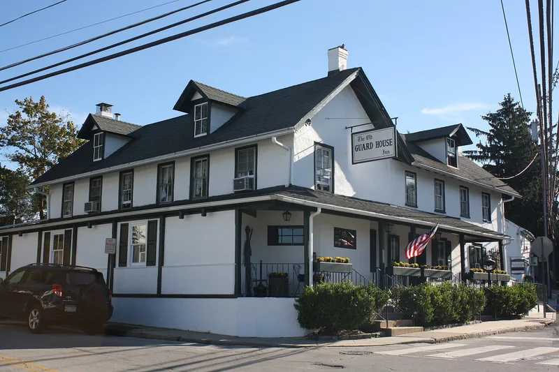
At the crossroads of Youngs Ford and Righters Mill Roads, about ten miles from central Philadelphia, lies a village of stone and stucco houses, shops and an inn that grew up in the late eighteenth and early nineteenth centuries. Known as Merion Square, it developed from land sales beginning around 1798, when George Helmbold built a stone house at the crossroads. Much of the village was served by nearby mills on Mill Creek and by papermakers who bought land there. The district holds 87 structures, with the mill and farm workers' house as its predominant type, often in stucco over rubble stone. Its buildings have changed little since the mid-1800s and retain a continuity of scale and materials, from the Georgian-era War Office to the Guard House Inn, which dates from several nineteenth-century stages. The village is regarded as one of the last intact examples of a Pennsylvania crossroads village.
Significance in brief: The village is significant for its continuity of building styles spanning almost 200 years and for its harmony of scale and materials, reflecting the nineteenth-century crossroads village that grew out of the surrounding mills and farms. Its development is tied to the Welsh Tract land history, the Mill Creek milling industry and papermaking, and the commercial life of the crossroads.
Machine-generated summary. This summary was generated by a language model from the official nomination document and has not been reviewed line by line by an editor. It may contain errors. Check the source document before relying on any detail. Source: nomination document (PDF) · National Archives catalog entry. NRHP reference 80003577, listed December 10, 1980. Summary generated October 2026 (model claude-haiku-5-5, prompt v1.1-2026-10-29, confidence medium).
Key facts
| Address | PA 23, Gladwyne |
|---|---|
| County | Montgomery County |
| Listed | December 10, 1980 |
| Reference number | 80003577 |
| Resource type | District |
| Period of significance | 1700-1899 |
| Criteria |
|
| Areas of significance | Commerce, Exploration/Settlement, Architecture |
| Level of significance | Local |
| Status (as stated in the nomination) | Largely extant, with alterations such as dormers and rear sheds; 18 structures are intrusions. |
| Acreage | 63.2 |
| Coordinates | 40.03628, -75.28208 (NPS GIS) |
What listing means for this property
This is a historic district. Buildings within its boundary are either contributing (they add to the district's significance) or non-contributing. Owners of contributing income-producing buildings can claim the 20% federal rehabilitation tax credit; homeowners should look at state credits. National Register districts impose no design review by themselves; a local historic district ordinance, if one exists, does (the difference explained).
General information, not legal or tax advice. Rules change; confirm with your State Historic Preservation Office or a qualified adviser.
Sources and further reading
- National Park Service, National Register of Historic Places database (snapshot May 2026), reference 80003577.
- Nomination form (PDF, National Archives) — catalog entry
- Wikipedia article (used for cross-checking only; text not reproduced here)
- Wikidata Q5566375
- This listing as JSON
Last updated October 2026. Found an error? See the editorial policy for how to report it.