Old Harbor Reservation Parkways, Metropolitan Park System of Greater Boston
Also known as: The Strandway, Columbia Road, Gardner Way

Why it's listed
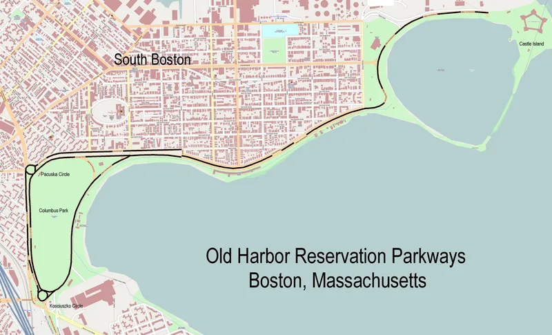
More than three miles of parkway line Old Harbor and Dorchester Bay in South Boston. The district includes William J. Day Boulevard, once known as the Strandway and Gardner Way, along with Columbia Road and part of Old Colony Avenue. The Boston Park Commission built the roads, and they passed to the Metropolitan District Commission between 1949 and 1955. The Strandway, developed from the 1890s, was one of the Olmsted firm's major planning and engineering projects. It required demolishing existing yacht clubs and shipyards, extensive landfill and a granite block sea wall topped by an iron railing. Columbia Road was laid out under the 1897 Parkways Act as a continuous route between Franklin Park and Farragut Road. Contributing features include the Farragut Rotary and Farragut Monument, a planted median with surviving early lampposts, and granite and Belgian-block curbing. Beaches, bathhouses, boat clubs and parks beside the roads shape the setting but lie outside the district boundary.
Significance in brief: The nomination presents the parkways as part of Boston's regional park system and as a major planning and engineering achievement of the Olmsted firm, notably the Strandway with its landfill, granite sea wall and relocated yacht clubs. It also covers Columbia Road, laid out under the 1897 Parkways Act to link Franklin Park with Marine Park, and the shoreline recreation areas along them.
Machine-generated summary. This summary was generated by a language model from the official nomination document and has not been reviewed line by line by an editor. It may contain errors. Check the source document before relying on any detail. Source: nomination document (PDF) · National Archives catalog entry. NRHP reference 08000693, listed July 24, 2008. Summary generated October 2026 (model claude-sonnet-5-5, prompt v1.0-2026-10-29, confidence medium).
Key facts
| Address | William J. Day Blvd., Columbia Rd. between Farragut Rd and Kosciuszko Cir., Old Colony Ave. between Pacuska Ave., Boston |
|---|---|
| County | Suffolk County |
| Listed | July 24, 2008 |
| Reference number | 08000693 |
| Resource type | District |
| Architect / builder | Olmsted firm (planning of the Strandway); Boston Park Commission (original builder) |
| Areas of significance | Community Planning and Development, Conservation, Engineering, Entertainment/Recreation, Landscape Architecture, Transportation |
| Level of significance | State |
| Status (as stated in the nomination) | Roads remain in use as parkways with recreational and transportation functions; some features, such as ginkgo trees in beach planters, are described as deteriorating. |
| Acreage | 55.8 |
| Coordinates | 42.33012, -71.04726 (NPS GIS) |
What listing means for this property
This is a historic district. Buildings within its boundary are either contributing (they add to the district's significance) or non-contributing. Owners of contributing income-producing buildings can claim the 20% federal rehabilitation tax credit; homeowners should look at state credits. National Register districts impose no design review by themselves; a local historic district ordinance, if one exists, does (the difference explained).
General information, not legal or tax advice. Rules change; confirm with your State Historic Preservation Office or a qualified adviser.
Sources and further reading
- National Park Service, National Register of Historic Places database (snapshot May 2026), reference 08000693.
- Nomination form (PDF, National Archives) — catalog entry
- Wikipedia article (used for cross-checking only; text not reproduced here)
- Wikidata Q7084173
- This listing as JSON
Last updated October 2026. Found an error? See the editorial policy for how to report it.