Billerica Mills Historic District

The pin is a point inside the NPS boundary polygon, not a surveyed location.
Why it's listed
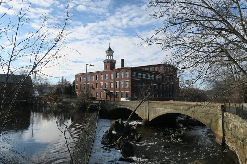
North Billerica's mill district lies along the Concord River and a mill pond first dammed in 1708, about 20 miles north of Boston. Two brick mill complexes face each other across the water: the five-story Talbot mill of 1857 and the three-story Faulkner mill of 1865. Around them are rows of company-built duplexes and multi-family blocks, churches, a school, a former tavern and older farmhouses, 123 structures in all on roughly 75 acres. Talbot Company housing, including a row of duplexes designed by the Lowell firm Stickney and Austin, makes up much of the streetscape. Landscape architect Warren Manning designed the Talbot Oval and the Kohlrausch Playground, giving the village planned open space. The area also holds traces of the Middlesex Canal, which drew water from the pond. The district was listed for its architecture, its association with the textile industry and the canal, and its cohesive planned setting, which has kept much of its early 20th century appearance.
Significance in brief: The nomination argues the district is one of the finer examples of rural industrial development in Massachusetts in the 19th and early 20th centuries. It has an orderly, varied streetscape and open spaces designed largely by landscape architect Warren Manning. It is also tied to the textile industry and the Middlesex Canal, and includes buildings that represent the work of notable area architectural firms.
Machine-generated summary. This summary was generated by a language model from the official nomination document and has not been reviewed line by line by an editor. It may contain errors. Check the source document before relying on any detail. Source: nomination document (PDF) · National Archives catalog entry. NRHP reference 83003996, listed November 10, 1983. Summary generated October 2026 (model claude-sonnet-5-5, prompt v1.0-2026-10-29, confidence high).
Key facts
| Address | Roughly bounded by Concord River, Treble Cove Terr., Kohlrausch Ave., Indian Rd., Holt Ruggles, and Rogers Sts., Billerica |
|---|---|
| County | Middlesex County |
| Listed | November 10, 1983 |
| Reference number | 83003996 |
| Resource type | District |
| Architect / builder | Warren E. Manning, landscape architect; Alexander E. Esty, architect; Stickney and Austin, architects |
| Architectural style | Federalist, Greek Revival, Italianate and Colonial Revival residences, with Georgian Revival and Victorian Gothic institutional buildings and brick mill complexes |
| Criteria |
|
| Areas of significance | Industry, Commerce, Transportation, Exploration/Settlement, Architecture |
| Level of significance | State |
| Status (as stated in the nomination) | Both mill complexes are described as well preserved and still in industrial or commercial use. The Talbot School is unused, some housing is in poor condition, and 15 of 123 structures are intrusions. |
| Acreage | 75 |
| Coordinates | 42.58960, -71.28631 (NPS GIS) |
What listing means for this property
This is a historic district. Buildings within its boundary are either contributing (they add to the district's significance) or non-contributing. Owners of contributing income-producing buildings can claim the 20% federal rehabilitation tax credit; homeowners should look at state credits. National Register districts impose no design review by themselves; a local historic district ordinance, if one exists, does (the difference explained).
General information, not legal or tax advice. Rules change; confirm with your State Historic Preservation Office or a qualified adviser.
Sources and further reading
- National Park Service, National Register of Historic Places database (snapshot May 2026), reference 83003996.
- Nomination form (PDF, National Archives) — catalog entry
- Wikipedia article (used for cross-checking only; text not reproduced here)
- Wikidata Q4911789
- This listing as JSON
Last updated October 2026. Found an error? See the editorial policy for how to report it.