Fairview Cemetery

Why it's listed
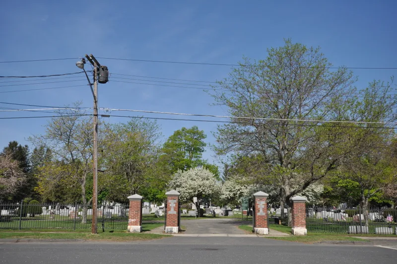
Fairview Cemetery occupies 6.3 acres a few blocks north of Main Street in Dalton, Massachusetts. Opened in 1885 and set aside by the town for its Catholic population, it holds more than 750 burial plots, mostly marked by gray granite headstones and chest-style monuments, many carved with crosses. Its layout combines curving gravel drives, recalling the rural cemetery movement, with a tidy grid of small, uniform lots designed for easier mowing and upkeep. Plantings are sparse compared with the older Main Street Cemetery, and markers are modest, reflecting the means of the working-class families who used it. A cast iron fence with granite-trimmed brick gateposts, built in 1921 and expanded in 1926, borders Curtis Avenue. Burial plots were provided free to town residents. The cemetery was listed for its landscape design, its artistic monuments and its place in the social history of Dalton's Irish-Catholic community between 1885 and 1950.
Significance in brief: The cemetery is argued to mark a transition between mid-nineteenth-century rural cemetery design, with curving drives and specimen plantings, and the later lawn-park approach with small grid-laid family plots that were easier to maintain. It also reflects the economic status and Catholic identity of Dalton's working and middle class immigrant community, and its markers show changing monument fashions through about 1950.
Machine-generated summary. This summary was generated by a language model from the official nomination document and has not been reviewed line by line by an editor. It may contain errors. Check the source document before relying on any detail. Source: nomination document (PDF) · National Archives catalog entry. NRHP reference 00000483, listed May 11, 2000. Summary generated October 2026 (model claude-sonnet-5-5, prompt v1.0-2026-10-29, confidence medium).
Key facts
| Address | Curtis Ave., Dalton |
|---|---|
| County | Berkshire County |
| Listed | May 11, 2000 |
| Reference number | 00000483 |
| Resource type | Site |
| Period of significance | 1885-1950 |
| Architect / builder | D.W. Dwyer (gateposts); Anchor Iron Works (iron fence) |
| Criteria |
|
| Areas of significance | Art, Landscape Architecture, Social History |
| Level of significance | Local |
| Status (as stated in the nomination) | Still used as a cemetery; grave markers are in good to excellent condition and the grounds are well preserved. No unclaimed lots remain, though some assigned plots are unused. |
| Acreage | 6.3 |
| Coordinates | 42.47697, -73.17196 (NPS GIS) |
What listing means for this property
Sites (archaeological sites, battlefields, landscapes) are often listed with a restricted address to protect them from looting or disturbance. Listing is honorary for private owners; federal undertakings on or near the site go through Section 106 review, and state laws may protect burials and artefacts regardless of listing.
General information, not legal or tax advice. Rules change; confirm with your State Historic Preservation Office or a qualified adviser.
Sources and further reading
- National Park Service, National Register of Historic Places database (snapshot May 2026), reference 00000483.
- Nomination form (PDF, National Archives) — catalog entry
- Wikipedia article (used for cross-checking only; text not reproduced here)
- Wikidata Q5430796
- This listing as JSON
Last updated October 2026. Found an error? See the editorial policy for how to report it.