Tri-Taylor Historic District

Why it's listed
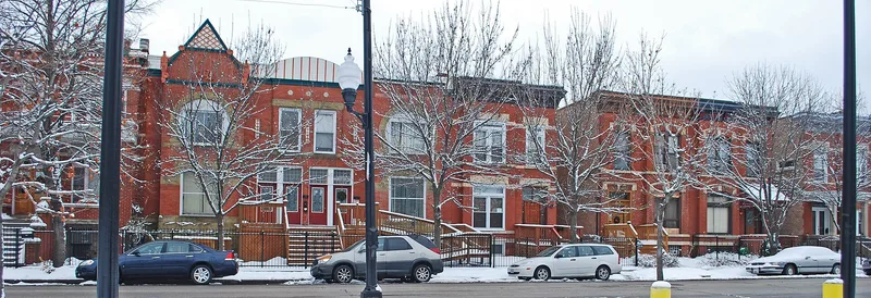
Tri-Taylor is a compact residential neighborhood on Chicago's Near West Side, about three miles from the Loop. It covers roughly 65 acres and holds nearly 400 buildings, most of them two- and three-story brick or frame row houses, apartments and cottages. Development moved from east to west between about 1870 and 1910. Streets differ in character: West Bowler has rare Joliet limestone row houses from the 1870s, South Oakley Boulevard has larger three-story homes from the 1880s, and South Claremont has a distinctive cluster of gabled houses with two-story bays. Local developers, including Alderman Campbell, built much of the housing, and the Campbell Flats row houses were designed by C.A. Weary. The neighborhood housed skilled German, Irish, Jewish and later Italian families who moved out from the crowded streets nearby. Its abundant applied ornament and consistent streetscape make it a record of late nineteenth-century Chicago building trades and immigrant social history.
Significance in brief: The district is argued to be a distinct urban and architectural ensemble and a distinct unit in Chicago's social history. It grew along the route taken by skilled immigrant families moving out of the crowded Near West Side after the 1871 fire. Its strength lies in the overall character of its masonry row houses and rich applied ornament rather than in a few standout buildings.
Machine-generated summary. This summary was generated by a language model from the official nomination document and has not been reviewed line by line by an editor. It may contain errors. Check the source document before relying on any detail. Source: nomination document (PDF) · National Archives catalog entry. NRHP reference 83000315, listed March 3, 1983. Summary generated October 2026 (model claude-sonnet-5-5, prompt v1.0-2026-10-29, confidence medium).
Key facts
| Address | Roughly bounded by Claremont, Harrison, Oakley, Polk, Ogden, and Roosevelt Rds., Chicago |
|---|---|
| County | Cook County |
| Listed | March 3, 1983 |
| Reference number | 83000315 |
| Resource type | District |
| Period of significance | 1870-1910 |
| Architect / builder | Various; Campbell Brothers, Builders, with designs by C.A. Weary and Edbrooke & Burnham noted for the Campbell Flats |
| Areas of significance | Architecture, Social History |
| Level of significance | Local |
| Status (as stated in the nomination) | Described as sound within its boundaries but frayed at the edges; the surrounding area has vacant land and intrusive medical center structures, and the form marks the condition as deteriorated and altered. |
| Acreage | 65 |
| Within district | Chicago Park Boulevard System Historic District |
| Coordinates | 41.87058, -87.68129 (NPS GIS) |
What listing means for this property
This is a historic district. Buildings within its boundary are either contributing (they add to the district's significance) or non-contributing. Owners of contributing income-producing buildings can claim the 20% federal rehabilitation tax credit; homeowners should look at state credits. National Register districts impose no design review by themselves; a local historic district ordinance, if one exists, does (the difference explained).
General information, not legal or tax advice. Rules change; confirm with your State Historic Preservation Office or a qualified adviser.
Sources and further reading
- National Park Service, National Register of Historic Places database (snapshot May 2026), reference 83000315.
- Nomination form (PDF, National Archives) — catalog entry
- Wikipedia article (used for cross-checking only; text not reproduced here)
- Wikidata Q60745039
- This listing as JSON
Last updated October 2026. Found an error? See the editorial policy for how to report it.