Lock and Dam No. 21 Historic District

Why it's listed
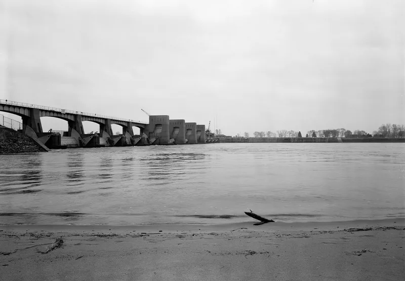
Lock and Dam No. 21 crosses the Upper Mississippi River just downstream from Quincy, Illinois. The 107.46-acre district includes a lift lock with a 10.5-foot lift, an incomplete auxiliary lock, a dam with ten Tainter gates and three submersible roller gates, a central control station, and a landscaped esplanade about 2,000 feet long. Most of it was built between 1933 and 1938 as a federal relief work project, and Quincy was favored in the construction order because of its severe unemployment. Joseph Meltzer Construction built the lock, and McCarthy Improvement Company built the dam, which opened to navigation on July 23, 1938. The roller gates, designed in 1936 to submerge only 4.67 feet, served as the model for later gates on the river system. Guard wall and guide wall additions in 1942 and 1951 addressed outdraft problems at the lock entrance. A major rehabilitation between 1985 and 1994 replaced much of the machinery and added new buildings, yet the district keeps its original layout and open river setting.
Significance in brief: The district is part of the Upper Mississippi River 9-Foot Navigation Project and is listed under Criterion A. Its roller gates helped shape the American-style submersible roller gate, and the project was moved up in the construction order to provide relief work in Quincy, which had acute unemployment. The district keeps its original configuration and setting.
Machine-generated summary. This summary was generated by a language model from the official nomination document and has not been reviewed line by line by an editor. It may contain errors. Check the source document before relying on any detail. Source: nomination document (PDF) · National Archives catalog entry. NRHP reference 04000181, listed March 10, 2004. Summary generated October 2026 (model claude-sonnet-5-5, prompt v1.0-2026-10-29, confidence medium).
Key facts
| Address | 0.5 mi. W of IL 57, Quincy |
|---|---|
| County | Adams County |
| Listed | March 10, 2004 |
| Reference number | 04000181 |
| Resource type | District |
| Architect / builder | Joseph Meltzer Construction (lock, control station, esplanade); McCarthy Improvement Company of Davenport, Iowa (dam); designed by Rock Island District engineers, U.S. Army Corps of Engineers |
| Architectural style | OTHER: lock and dam; NO STYLE: control station; OTHER: machinery |
| Criteria |
|
| Areas of significance | Transportation, Maritime History, Social History, Commerce, Conservation, Economics, Politics/Government, Military |
| Level of significance | National |
| Status (as stated in the nomination) | In continuous use as part of the Upper Mississippi River 9-Foot Channel Project since July 23, 1938; the form rates condition as excellent after a 1985-1994 major rehabilitation. |
| Acreage | 107.5 |
| Coordinates | 39.90621, -91.43141 (NPS GIS) |
What listing means for this property
This is a historic district. Buildings within its boundary are either contributing (they add to the district's significance) or non-contributing. Owners of contributing income-producing buildings can claim the 20% federal rehabilitation tax credit; homeowners should look at state credits. National Register districts impose no design review by themselves; a local historic district ordinance, if one exists, does (the difference explained).
General information, not legal or tax advice. Rules change; confirm with your State Historic Preservation Office or a qualified adviser.
Sources and further reading
- National Park Service, National Register of Historic Places database (snapshot May 2026), reference 04000181.
- Nomination form (PDF, National Archives) — catalog entry
- Wikipedia article (used for cross-checking only; text not reproduced here)
- Wikidata Q1867486
- This listing as JSON
Last updated October 2026. Found an error? See the editorial policy for how to report it.