Myrtle Street Flats

Why it's listed
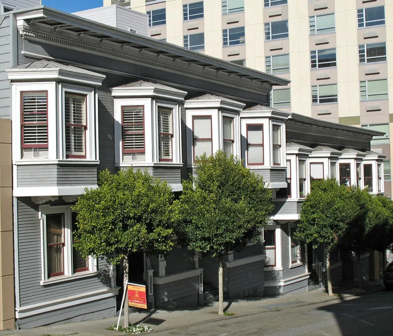
Two matching two-story frame apartment buildings at 234-248 Myrtle Street in San Francisco, each with four dwelling units, make up the Myrtle Street Flats. They were built after the 1906 earthquake, when Abraham Goodman enlarged the neighboring Emeric Building on Geary Street and added eight apartments facing Myrtle Street. Each facade has four evenly spaced bay windows on the upper floor, and the entrance stairs below the center bays are angled about 45 degrees to the sidewalk, a feature a local landmarks board leader described as found in no other San Francisco building. The flats share a foundation and a roof connection with the Goodman Building, and a single wall separates them. The nomination presents them as a rare surviving example of the housing and commercial building that followed the fire, when Van Ness Avenue became the city's new commercial center. They were described as unoccupied at the time of listing.
Significance in brief: The nomination argues the flats have an unusual design, with entrance stairs set at about a 45-degree angle to the sidewalk, which the San Francisco Landmarks Preservation Advisory Board president called unique in the city. They are also described as part of the only surviving example in this part of San Francisco of post-earthquake development along Van Ness Avenue. The flats are physically tied to the Goodman Building and are said to have more design integrity than it.
Machine-generated summary. This summary was generated by a language model from the official nomination document and has not been reviewed line by line by an editor. It may contain errors. Check the source document before relying on any detail. Source: nomination document (PDF) · National Archives catalog entry. NRHP reference 76000520, listed June 14, 1976. Summary generated October 2026 (model claude-sonnet-5-5, prompt v1.0-2026-10-29, confidence medium).
Key facts
| Address | 234--248 Myrtle St., San Francisco |
|---|---|
| County | San Francisco |
| Listed | June 14, 1976 |
| Reference number | 76000520 |
| Resource type | Building |
| Period of significance | 1900- |
| Areas of significance | Architecture |
| Level of significance | State |
| Status (as stated in the nomination) | Marked private ownership and unoccupied; owned by the San Francisco Redevelopment Agency, with demolition proposed and a condemnation notice issued in related papers. |
| Acreage | 0.1 |
| Coordinates | 37.78553, -122.42235 (NPS GIS) |
What listing means for this property
National Register listing is honorary: it recognises significance and does not restrict what a private owner may do without federal money or permits. It unlocks the 20% federal rehabilitation tax credit for income-producing buildings, state credits in many states, and Section 106 review when federal agencies are involved. See what listing means in practice.
Noted as vacant in the nomination. Nomination documents can be decades old; current status may differ. If you are considering buying an empty listed property, read the due-diligence checklist.
General information, not legal or tax advice. Rules change; confirm with your State Historic Preservation Office or a qualified adviser.
Sources and further reading
- National Park Service, National Register of Historic Places database (snapshot May 2026), reference 76000520.
- Nomination form (PDF, National Archives) — catalog entry
- Wikidata Q133480532
- This listing as JSON
Last updated October 2026. Found an error? See the editorial policy for how to report it.