Cedar Hill
Also known as: Cress Farm; VDHR File No. 81-19

Why it's listed
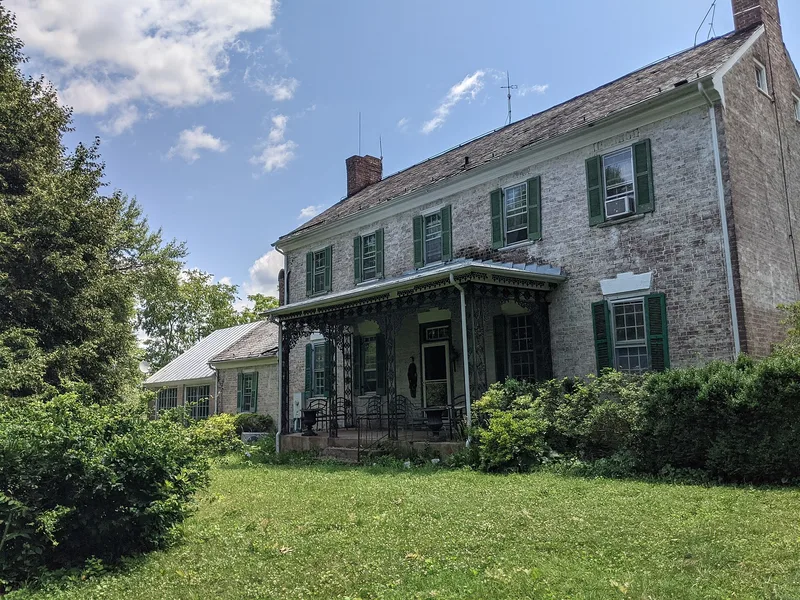
Cedar Hill is a farm on a limestone hill beside State Route 608, east of the Maury River near Buena Vista in Rockbridge County. Its main house, completed around 1821, is a five-bay, two-story brick I-house laid in Flemish bond, with a central hall, slate roof and gable-end chimneys. A one-and-a-half-story brick addition was in place by 1827, and another extension followed in 1971. Inside are paneled doors, wainscoting and distinctive carved mantels of unknown craftsmanship. Nearby stand two early log outbuildings, a stone springhouse, and several farm buildings from the early 1900s, along with the ruins of an earlier dwelling and a stretch of abandoned roadbed. Subdivision in the 1920s and 1930s reduced the farm to about 46 acres, yet it continues to operate. Listing recognized the house as a well-preserved example of the Valley of Virginia I-house and a representative early farm of the upper valley, with additions that respect the original design.
Significance in brief: The nomination argues Cedar Hill is an excellent example of a vernacular Valley of Virginia I-house and a representative early farm of the upper valley. Additions over time were made in harmony with the original design. The log outbuildings, springhouse, early dwelling site and old roadbed add to its local significance as a surviving working farm.
Machine-generated summary. This summary was generated by a language model from the official nomination document and has not been reviewed line by line by an editor. It may contain errors. Check the source document before relying on any detail. Source: nomination document (PDF) · National Archives catalog entry. NRHP reference 94000726, listed July 15, 1994. Summary generated October 2026 (model claude-sonnet-5-5, prompt v1.0-2026-10-29, confidence high).
Key facts
| Address | VA 608 E side, 2.25 mi. S of jct. with US 60, Buena Vista |
|---|---|
| County | Rockbridge County |
| Listed | July 15, 1994 |
| Reference number | 94000726 |
| Resource type | Building |
| Period of significance | 1821-1910 |
| Architectural style | Early Republic: Federal (vernacular I-house) |
| Criteria |
|
| Areas of significance | Architecture |
| Level of significance | Local |
| Status (as stated in the nomination) | Continuously occupied and maintained; the property still operates as a farm and all buildings remain in use. |
| Acreage | 46.4 |
| Coordinates | 37.71706, -79.39794 (NPS GIS) |
What listing means for this property
National Register listing is honorary: it recognises significance and does not restrict what a private owner may do without federal money or permits. It unlocks the 20% federal rehabilitation tax credit for income-producing buildings, state credits in many states, and Section 106 review when federal agencies are involved. See what listing means in practice.
General information, not legal or tax advice. Rules change; confirm with your State Historic Preservation Office or a qualified adviser.
Sources and further reading
- National Park Service, National Register of Historic Places database (snapshot May 2026), reference 94000726.
- Nomination form (PDF, National Archives) — catalog entry
- Wikipedia article (used for cross-checking only; text not reproduced here)
- Wikidata Q15208213
- This listing as JSON
Last updated October 2026. Found an error? See the editorial policy for how to report it.