Shockoe Slip Historic District
Also known as: See Also:Shockoe Slip Historic District Boundary Increase; Do

Why it's listed
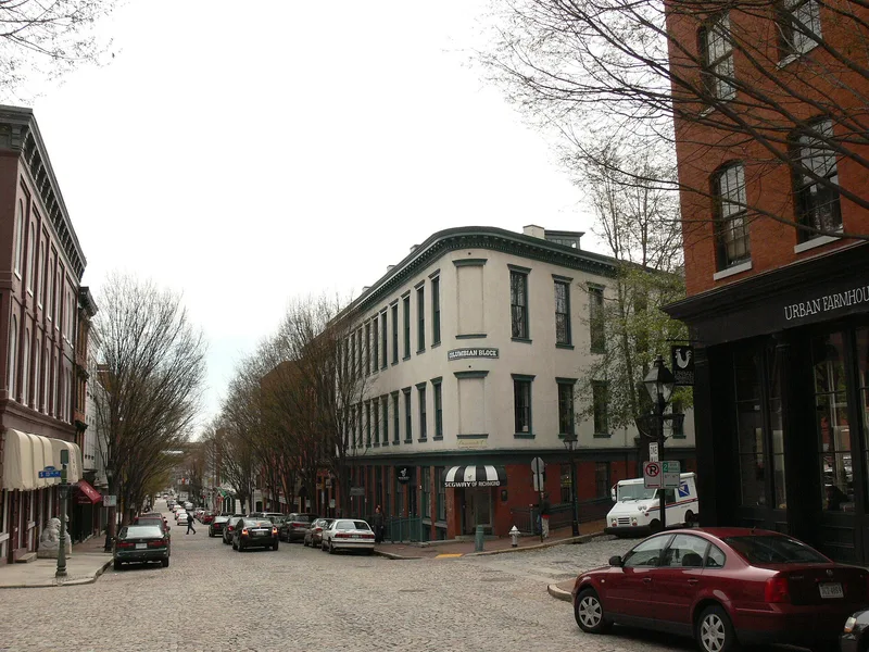
Shockoe Slip is a compact commercial neighborhood in downtown Richmond, built around a triangular, stone-paved plaza with a fountain at South Thirteenth and East Cary Streets. Warehouses, tobacco storage buildings and mills stood here as early as the eighteenth century, and the area was rebuilt after a fire in April 1865. The surviving buildings are mostly two to four stories of red pressed brick, with corbeled cornices, segmental-arched windows and storefronts framed by cast-iron columns and pilasters. Several warehouses faced the Great Basin of the James River and Kanawha Canal, linking the district to the canal trade. The Columbian Block, built in 1871 with Italianate features, anchors the plaza. The nomination values the district for its consistent scale, its rhythm of repeated three-bay fronts and its brick and ironwork. Later documentation notes its transformation from a blighted area into a restaurant, retail and visitor destination, and an expanded boundary that takes in nearby warehouse and railroad structures.
Significance in brief: The nomination argues that the district preserves a cohesive late-nineteenth-century brick and cast-iron commercial neighborhood, with repeated three-bay units, corbeled cornices and segmental-arched windows. It is also tied to the James River and Kanawha Canal trade. A later addition describes it as a notable preservation success and a visitor focal point.
Machine-generated summary. This summary was generated by a language model from the official nomination document and has not been reviewed line by line by an editor. It may contain errors. Check the source document before relying on any detail. Source: nomination document (PDF) · National Archives catalog entry. NRHP reference 72001526, listed March 29, 1972. Summary generated October 2026 (model claude-sonnet-5-5, prompt v1.0-2026-10-29, confidence medium).
Key facts
| Address | Roughly along E. Carey St. between S. 14th and S. 12 Sts., Richmond (Independent City) |
|---|---|
| County | Richmond (city and county) |
| Listed | March 29, 1972 |
| Reference number | 72001526 |
| Resource type | District |
| Architectural style | Italianate and High Victorian Italianate commercial buildings with cast-iron storefronts |
| Areas of significance | Commerce, Transportation, Architecture |
| Level of significance | State |
| Status (as stated in the nomination) | Condition is given as good and unaltered. Some buildings listed in the original inventory were later damaged or demolished, including 1019-21, 1107-13 and 1117 East Cary Street in 1974. The later addition describes restaurants and retail shops alongside warehouses and small factories. |
| Acreage | 10 |
| Within district | James River and Kanawha Canal Historic District |
| Coordinates | 37.53545, -77.43328 (NPS GIS) |
What listing means for this property
This is a historic district. Buildings within its boundary are either contributing (they add to the district's significance) or non-contributing. Owners of contributing income-producing buildings can claim the 20% federal rehabilitation tax credit; homeowners should look at state credits. National Register districts impose no design review by themselves; a local historic district ordinance, if one exists, does (the difference explained).
General information, not legal or tax advice. Rules change; confirm with your State Historic Preservation Office or a qualified adviser.
Sources and further reading
- National Park Service, National Register of Historic Places database (snapshot May 2026), reference 72001526.
- Nomination form (PDF, National Archives) — catalog entry
- Wikipedia article (used for cross-checking only; text not reproduced here)
- Wikidata Q7499926
- This listing as JSON
Last updated October 2026. Found an error? See the editorial policy for how to report it.