Soldier's Rest
Also known as: VDHR File No. 21-73

Why it's listed
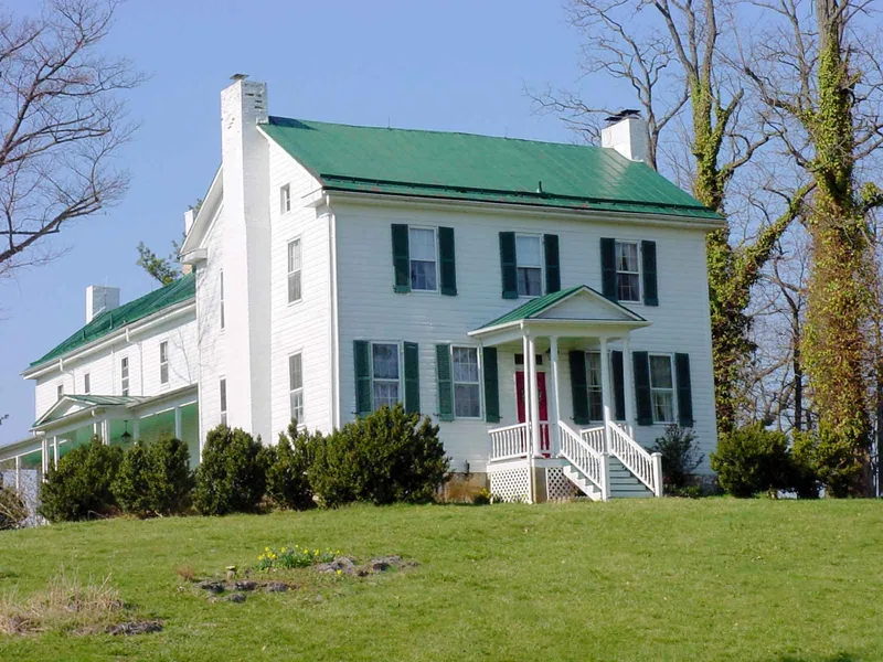
Soldier's Rest is a large two-story frame house on the northeastern edge of Berryville, Clarke County, Virginia, now surrounded by 22 acres of pastureland. The front block was built between 1774 and 1785 for William and Rebecca Morton on land first settled by Isaac Pennington in the 1730s. In the 1830s the main block was remodeled in the late Federal style, its hall-parlor plan was changed to a central passage, and a long rear wing was added. The house is among the county's earliest frame dwellings and remains little changed since an artist traveling with Gen. Philip Sheridan sketched it in 1864. Gen. Daniel Morgan briefly owned it in 1800, and local tradition links it to George Washington's surveying, though the nomination says the Washington story cannot be proved. Col. Griffin Taylor, a War of 1812 veteran, acquired it in the 1810s and probably named it. Its architecture and intact rural setting make it locally significant.
Significance in brief: The nomination argues the house is one of Clarke County's earliest frame dwellings still in relatively unaltered condition, and it is locally significant under Criterion C for its form, details and pristine setting. Associations with Gen. Daniel Morgan, George Washington and Col. Griffin Taylor add to its importance. An 1864 sketch by James E. Taylor shows the house much as it appears today.
Machine-generated summary. This summary was generated by a language model from the official nomination document and has not been reviewed line by line by an editor. It may contain errors. Check the source document before relying on any detail. Source: nomination document (PDF) · National Archives catalog entry. NRHP reference 96000579, listed May 23, 1996. Summary generated October 2026 (model claude-sonnet-5-5, prompt v1.0-2026-10-29, confidence medium).
Key facts
| Address | .3 mi N of Fairfax Ave., approximately .5 mi. E of jct. of US 340 and VA 7, Berryville |
|---|---|
| County | Clarke County |
| Listed | May 23, 1996 |
| Reference number | 96000579 |
| Resource type | Building |
| Architectural style | Federal |
| Criteria |
|
| Areas of significance | Architecture |
| Level of significance | Local |
| Status (as stated in the nomination) | Still in use as a single dwelling, with a secondary structure and agricultural outbuildings; the house is described as well preserved. |
| Acreage | 22 |
| Coordinates | 39.15750, -77.97060 (NPS GIS) |
What listing means for this property
National Register listing is honorary: it recognises significance and does not restrict what a private owner may do without federal money or permits. It unlocks the 20% federal rehabilitation tax credit for income-producing buildings, state credits in many states, and Section 106 review when federal agencies are involved. See what listing means in practice.
General information, not legal or tax advice. Rules change; confirm with your State Historic Preservation Office or a qualified adviser.
Sources and further reading
- National Park Service, National Register of Historic Places database (snapshot May 2026), reference 96000579.
- Nomination form (PDF, National Archives) — catalog entry
- Wikipedia article (used for cross-checking only; text not reproduced here)
- Wikidata Q7557252
- This listing as JSON
Last updated October 2026. Found an error? See the editorial policy for how to report it.