Fort Meigs

Why it's listed
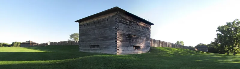
Fort Meigs is a War of 1812 fort site on the Maumee River near Perrysburg, Ohio. Begun in early 1813 under General William Henry Harrison, it covered about eight acres, with earth and picket walls, seven blockhouses, five batteries and a long earthen embankment called the Grand Traverse. In May 1813 British and Indian forces besieged it for five days but failed to take it, an outcome that began the decline of British power in the Old Northwest. The fort was abandoned in 1815 and passed to the State of Ohio in 1907. Today the stockade, blockhouses and batteries are reconstructions on the original locations, and an 80-foot monument from 1908 stands at the center. Archaeological work also found a prehistoric village midden from roughly the fourteenth and fifteenth centuries. It shows a culture related to the Whittlesey phase and is the only such site known in the Maumee Valley.
Significance in brief: The fort was the scene of the five-day British and Indian siege of May 1-5, 1813, which failed to capture Harrison's Northern Army. The failure marked the beginning of the end of British control of the Old Northwest. The site also holds a prehistoric Upper Mississippian village midden that is the only known example of its assemblage in the Maumee Valley.
Machine-generated summary. This summary was generated by a language model from the official nomination document and has not been reviewed line by line by an editor. It may contain errors. Check the source document before relying on any detail. Source: nomination document (PDF) · National Archives catalog entry. NRHP reference 69000151, listed August 4, 1969. Summary generated October 2026 (model claude-sonnet-5-5, prompt v1.0-2026-10-29, confidence medium).
Key facts
| Address | 1.3 mi. SW of Perrysburg, Perrysburg |
|---|---|
| County | Wood County |
| Listed | August 4, 1969 |
| Reference number | 69000151 |
| Resource type | Site |
| Period of significance | May 1st - May 5th, 1813 |
| Architect / builder | General William Henry Harrison (directed construction) |
| Areas of significance | Military |
| Level of significance | National |
| National Historic Landmark | Yes, designated August 4, 1969 |
| Status (as stated in the nomination) | Operated by the Ohio Historical Society as a state memorial and park. The stockade, seven blockhouses and batteries have been reconstructed, and the condition is rated good to excellent. |
| Acreage | 10 |
| Coordinates | 41.55277, -83.65146 (NPS GIS) |
What listing means for this property
Sites (archaeological sites, battlefields, landscapes) are often listed with a restricted address to protect them from looting or disturbance. Listing is honorary for private owners; federal undertakings on or near the site go through Section 106 review, and state laws may protect burials and artefacts regardless of listing.
General information, not legal or tax advice. Rules change; confirm with your State Historic Preservation Office or a qualified adviser.
Sources and further reading
- National Park Service, National Register of Historic Places database (snapshot May 2026), reference 69000151.
- Nomination form (PDF, National Archives) — catalog entry
- Wikipedia article (used for cross-checking only; text not reproduced here)
- Wikidata Q5471670
- This listing as JSON
Last updated October 2026. Found an error? See the editorial policy for how to report it.