Lower Price Hill Historic District

Why it's listed
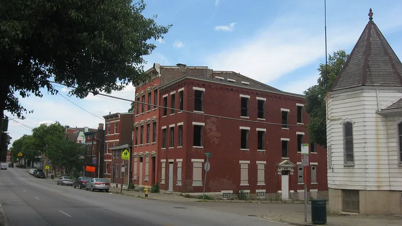
Lower Price Hill is a tightly packed Cincinnati neighborhood of roughly 25 acres at the eastern foot of Price Hill, beside the Mill Creek industrial valley. Its 206 buildings are mostly brick, and most were built to the sidewalk on long, narrow lots. Italianate multi-family houses dominate, with bracketed metal cornices and stone or metal window surrounds, reflecting the area's main growth in the 1870s and 1880s. Other building types add variety: corner commercial blocks with cast iron or stone storefronts, one-story brick rows, two churches, and two schools. Notable examples include the terra cotta Neo-Classical West End Bank Building, the Queen Anne and Colonial Revival Radel Funeral Home, and the 1930 Oyler School, designed by Samuel Hannaford & Sons and decorated with Rookwood tile. Industrial buildings along Burns Street show how factories and homes once stood side by side. The district was listed for this cohesive architecture and the intact streetscapes built mostly by 1938.
Significance in brief: The district is significant for its concentration of Italianate brick multi-family residences, which make up about 85% of the housing stock, along with churches, schools, commercial and industrial buildings in other styles. Its dense, unified streetscapes retain a high degree of integrity. It also reflects a self-sufficient working neighborhood that grew beside the Mill Creek valley's canal, railroad and industry.
Machine-generated summary. This summary was generated by a language model from the official nomination document and has not been reviewed line by line by an editor. It may contain errors. Check the source document before relying on any detail. Source: nomination document (PDF) · National Archives catalog entry. NRHP reference 88002536, listed November 15, 1988. Summary generated October 2026 (model claude-sonnet-5-5, prompt v1.0-2026-10-29, confidence medium).
Key facts
| Address | Roughly bounded by W. 8th, State, Burns, and English St., Cincinnati |
|---|---|
| County | Hamilton County |
| Listed | November 15, 1988 |
| Reference number | 88002536 |
| Resource type | District |
| Period of significance | Begins with the first subdivision and construction of St. Michael's Church and ends in 1938 (exact start year not visible in the provided text) |
| Architect / builder | Samuel Hannaford & Sons (Oyler School) |
| Architectural style | Italianate, with Queen Anne, Classical Revival, Neo-Classical, Art Deco/Italian Romanesque, Gothic Revival and Art Moderne examples |
| Areas of significance | Architecture |
| Level of significance | Local |
| Status (as stated in the nomination) | Contains 196 contributing buildings and 16 noncontributing resources, including 4 sites from demolitions. Some upper stories and storefronts on W. Eighth Street are vacant or boarded up. |
| Acreage | 25 |
| Coordinates | 39.10377, -84.55203 (NPS GIS) |
What listing means for this property
This is a historic district. Buildings within its boundary are either contributing (they add to the district's significance) or non-contributing. Owners of contributing income-producing buildings can claim the 20% federal rehabilitation tax credit; homeowners should look at state credits. National Register districts impose no design review by themselves; a local historic district ordinance, if one exists, does (the difference explained).
General information, not legal or tax advice. Rules change; confirm with your State Historic Preservation Office or a qualified adviser.
Sources and further reading
- National Park Service, National Register of Historic Places database (snapshot May 2026), reference 88002536.
- Nomination form (PDF, National Archives) — catalog entry
- Wikipedia article (used for cross-checking only; text not reproduced here)
- Wikidata Q6693727
- This listing as JSON
Last updated October 2026. Found an error? See the editorial policy for how to report it.