Anderson Ferry

Why it's listed
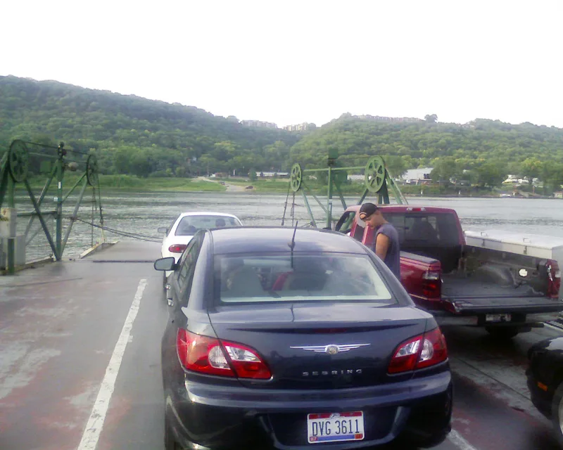
Anderson Ferry is a working river crossing on the Ohio River, linking western Cincinnati, Ohio, with Constance, Kentucky. The nominated district covers about 1.2 acres on the Ohio shore and 7.4 acres on the Kentucky shore, including a small farm complex of a house, a barn and outbuildings near the Kentucky landing. Two boats serve the crossing. Boone #7, built in 1937 of steel plate, is a double-ended diesel side-paddlewheel ferry. Little Boone, built in 1952, is a barge pushed by a work boat on a pivot hitch. George Anderson bought an existing ferry in 1817, and Charles Kottmyer purchased it in 1865; the Kottmyer family has operated it since, building several boats. The ferry predates the area's first permanent bridge and still provides a link between the two states. Review comments treated the 1937 boat as contributing, while the 1952 boat was considered too recent.
Significance in brief: The ferry is significant in transportation for its long, continuous service carrying people, goods and vehicles across the Ohio River. It operated before the first permanent bridge in the area opened in 1866 and still operates. The land around the landings keeps an open, rural character that conveys a sense of place for the crossing.
Machine-generated summary. This summary was generated by a language model from the official nomination document and has not been reviewed line by line by an editor. It may contain errors. Check the source document before relying on any detail. Source: nomination document (PDF) · National Archives catalog entry. NRHP reference 82003575, listed June 10, 1982. Summary generated October 2026 (model claude-sonnet-5-5, prompt v1.0-2026-10-29, confidence medium).
Key facts
| Address | Off U.S. 50, Cincinnati |
|---|---|
| County | Hamilton County |
| Listed | June 10, 1982 |
| Reference number | 82003575 |
| Resource type | District |
| Period of significance | 1817 |
| Criteria |
|
| Areas of significance | Transportation |
| Level of significance | State |
| Status (as stated in the nomination) | The ferry remains in active commercial operation, running about 15 hours a day. The nomination describes it as carrying 150-200 vehicles when river conditions permit. |
| Acreage | 8.6 |
| Coordinates | 39.07652, -84.62438 (NPS GIS) |
What listing means for this property
This is a historic district. Buildings within its boundary are either contributing (they add to the district's significance) or non-contributing. Owners of contributing income-producing buildings can claim the 20% federal rehabilitation tax credit; homeowners should look at state credits. National Register districts impose no design review by themselves; a local historic district ordinance, if one exists, does (the difference explained).
General information, not legal or tax advice. Rules change; confirm with your State Historic Preservation Office or a qualified adviser.
Sources and further reading
- National Park Service, National Register of Historic Places database (snapshot May 2026), reference 82003575.
- Nomination form (PDF, National Archives) — catalog entry
- Wikipedia article (used for cross-checking only; text not reproduced here)
- Wikidata Q4754065
- This listing as JSON
Last updated October 2026. Found an error? See the editorial policy for how to report it.