Brevard College Stone Fence and Gate

Why it's listed
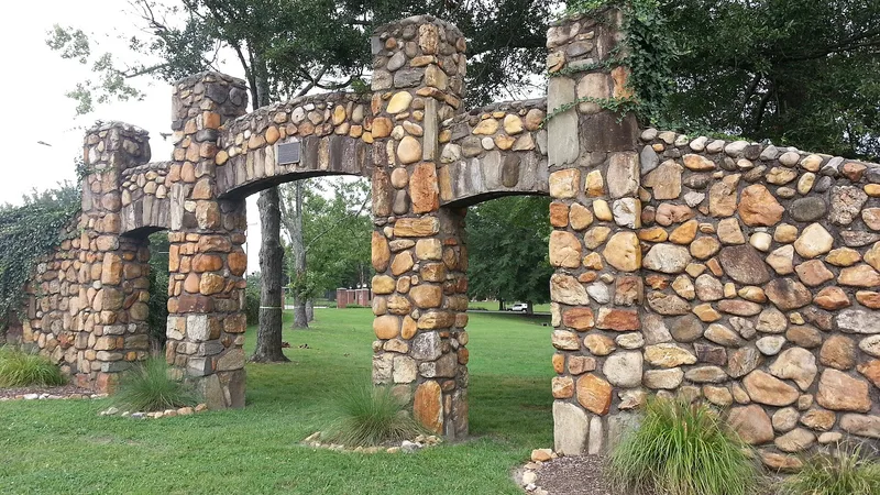
Along North Broad Street and French Broad Avenue in Brevard, a long stone wall wraps the southwest corner of the Brevard College campus. Built in 1936-1937 by the Works Progress Administration, it enclosed a new college athletic field. Local tradition holds that students and workmen gathered the yellow and grey river rock from the Davidson River. The wall runs about 222 feet on one street and 252 feet on the other, with blind sections between square piers, and a diagonal arcaded gate with three segmental-arched openings joins the two arms. The college opened in 1934 on the grounds of the former Brevard Institute, and this fence and gate is the earliest surviving structure built specifically for it. The athletic facilities have since moved to the northeast part of the campus, leaving the wall as a reminder of the college's early years and of the ties between students and townspeople. It is also an example of the stone construction that marked Brevard between 1915 and 1943.
Significance in brief: It is the earliest surviving structure built specifically for Brevard College at this location and is the only surviving feature of the WPA athletic field project. It also symbolizes the link between the college and the town. It is one of a small number of impressive stone buildings and structures built in Brevard between 1915 and 1943.
Machine-generated summary. This summary was generated by a language model from the official nomination document and has not been reviewed line by line by an editor. It may contain errors. Check the source document before relying on any detail. Source: nomination document (PDF) · National Archives catalog entry. NRHP reference 93001436, listed December 21, 1993. Summary generated October 2026 (model claude-sonnet-5-5, prompt v1.0-2026-10-29, confidence high).
Key facts
| Address | Jct. of N. Broad St. and French Broad Ave., NW corner, Brevard |
|---|---|
| County | Transylvania County |
| Listed | December 21, 1993 |
| Reference number | 93001436 |
| Resource type | Structure |
| Period of significance | 1936-1937 |
| Architect / builder | Unknown (erected by the Works Progress Administration) |
| Architectural style | Late 19th and Early 20th Century American Movement/Craftsman |
| Criteria |
|
| Areas of significance | Architecture |
| Level of significance | Local |
| Status (as stated in the nomination) | Described as unaltered, though about thirty-three feet at the southeastern end was removed at some past time; the former athletic field inside is now lawn. |
| Acreage | 0.9 |
| Coordinates | 35.23856, -82.73031 (NPS GIS) |
What listing means for this property
For a publicly owned building or structure, listing mainly matters when federal funds, permits or licences are involved: projects then go through Section 106 review so effects on the property are considered. Listing also strengthens applications for preservation grants and, for leased income-producing uses, can enable the federal rehabilitation tax credit.
General information, not legal or tax advice. Rules change; confirm with your State Historic Preservation Office or a qualified adviser.
Sources and further reading
- National Park Service, National Register of Historic Places database (snapshot May 2026), reference 93001436.
- Nomination form (PDF, National Archives) — catalog entry
- Wikipedia article (used for cross-checking only; text not reproduced here)
- Wikidata Q19986545
- This listing as JSON
Last updated October 2026. Found an error? See the editorial policy for how to report it.