Tarrytown Lighthouse

Why it's listed
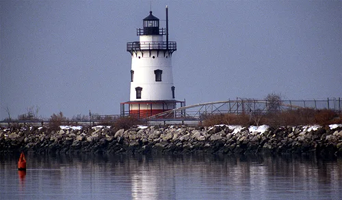
Built in 1882-1883, this lighthouse rises from a stone pier in the Hudson River just south of Kingsland Point Park. It is a steel conical tower of five stories, a cellar and a lantern deck, painted white with a black lantern room and a red pier. Originally about half a mile offshore on a reef at the end of the Tarrytown shoals, it now sits about one hundred feet from land because the neighboring General Motors plant expanded. A footbridge built by Westchester County in 1975 connects it to the shore. Living quarters filled the lower floors, with a workshop and the fog bell mechanisms above. It was meant to warn river traffic away from a hazardous area when commerce on the Hudson was at its height. The tower is noted as the only conical steel lighthouse in its thematic group with living quarters, and the only lighthouse in Westchester County. It was automated in 1957 and its light went dark in 1961.
Significance in brief: The nomination calls it the only conical steel structure in the Hudson River lighthouse thematic group to have living quarters, the only family station in the lower Hudson, and the only lighthouse in Westchester County. It was built to mark a dangerous area off the Tarrytown shoals when river commerce was at its peak. The form lists themes of maritime history, architecture and transportation.
Machine-generated summary. This summary was generated by a language model from the official nomination document and has not been reviewed line by line by an editor. It may contain errors. Check the source document before relying on any detail. Source: nomination document (PDF) · National Archives catalog entry. NRHP reference 79001649, listed May 29, 1979. Summary generated October 2026 (model claude-sonnet-5-5, prompt v1.0-2026-10-29, confidence medium).
Key facts
| Address | Spans Hudson River, Sleepy Hollow |
|---|---|
| County | Westchester County |
| Listed | May 29, 1979 |
| Reference number | 79001649 |
| Resource type | Structure |
| Areas of significance | Commerce, Transportation, Architecture |
| Level of significance | State |
| Status (as stated in the nomination) | Present use is listed as none; condition is given as good. The light was automated in 1957 and deactivated in 1961. The structure is now reached by a footbridge and is part of Kingsland Point Park. |
| Acreage | 0.9 |
| Coordinates | 41.08409, -73.87383 (NPS GIS) |
What listing means for this property
For a publicly owned building or structure, listing mainly matters when federal funds, permits or licences are involved: projects then go through Section 106 review so effects on the property are considered. Listing also strengthens applications for preservation grants and, for leased income-producing uses, can enable the federal rehabilitation tax credit.
General information, not legal or tax advice. Rules change; confirm with your State Historic Preservation Office or a qualified adviser.
Sources and further reading
- National Park Service, National Register of Historic Places database (snapshot May 2026), reference 79001649.
- Nomination form (PDF, National Archives) — catalog entry
- Wikipedia article (used for cross-checking only; text not reproduced here)
- Wikidata Q7686723
- This listing as JSON
Last updated October 2026. Found an error? See the editorial policy for how to report it.