Sloat's Dam and Mill Pond

Why it's listed
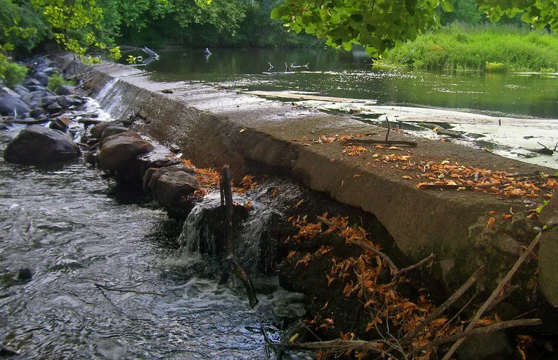
Sloat's Dam and Mill Pond is a surviving piece of the hydropower system that once drove the mills of Sloatsburg, in Rockland County, New York. Isaac Sloat built the first dam across the Ramapo River around 1792 to power a sawmill and tannery. His son Jacob later added a textile mill, and later owners made silk and finished textiles there until a fire destroyed the last mill in 1955. The site now includes the roughly 200-foot dam, strengthened with concrete and cobblestone end walls, along with a sluice gate, a raceway and the pond. Two cobblestone gateposts and stone walls from the former Brown Estate entrance also stand within the boundary. Two other early dams in the area were washed out or damaged by floods, leaving this system as the only one largely intact. It was listed for its engineering, commercial and community development importance, and local groups hope to turn it into a historical park.
Significance in brief: The nomination argues it is the sole surviving remnant of Sloatsburg's industrial center and the only intact one of three early hydropower systems in the area. Its dam, sluice, race and pond powered mills from the 1790s until 1955. It is listed under Criteria A and C for engineering, commerce and community development.
Machine-generated summary. This summary was generated by a language model from the official nomination document and has not been reviewed line by line by an editor. It may contain errors. Check the source document before relying on any detail. Source: nomination document (PDF) · National Archives catalog entry. NRHP reference 00000344, listed April 6, 2000. Summary generated October 2026 (model claude-sonnet-5-5, prompt v1.0-2026-10-29, confidence high).
Key facts
| Address | Off of Station Rd., Sloatsburg |
|---|---|
| County | Rockland County |
| Listed | April 6, 2000 |
| Reference number | 00000344 |
| Resource type | Structure |
| Period of significance | ca.1792-1949 |
| Criteria |
|
| Areas of significance | Engineering, Commerce, Community Planning and Development |
| Level of significance | Local |
| Status (as stated in the nomination) | The mills burned in 1955 and were demolished in 1966. The dam, sluice, race and pond survive within an undeveloped county park, with the features described as abandoned for nearly half a century. |
| Acreage | 15 |
| Coordinates | 41.15796, -74.18908 (NPS GIS) |
What listing means for this property
For a publicly owned building or structure, listing mainly matters when federal funds, permits or licences are involved: projects then go through Section 106 review so effects on the property are considered. Listing also strengthens applications for preservation grants and, for leased income-producing uses, can enable the federal rehabilitation tax credit.
General information, not legal or tax advice. Rules change; confirm with your State Historic Preservation Office or a qualified adviser.
Sources and further reading
- National Park Service, National Register of Historic Places database (snapshot May 2026), reference 00000344.
- Nomination form (PDF, National Archives) — catalog entry
- Wikipedia article (used for cross-checking only; text not reproduced here)
- Wikidata Q777340
- This listing as JSON
Last updated October 2026. Found an error? See the editorial policy for how to report it.