Wall Street Historic District

Why it's listed
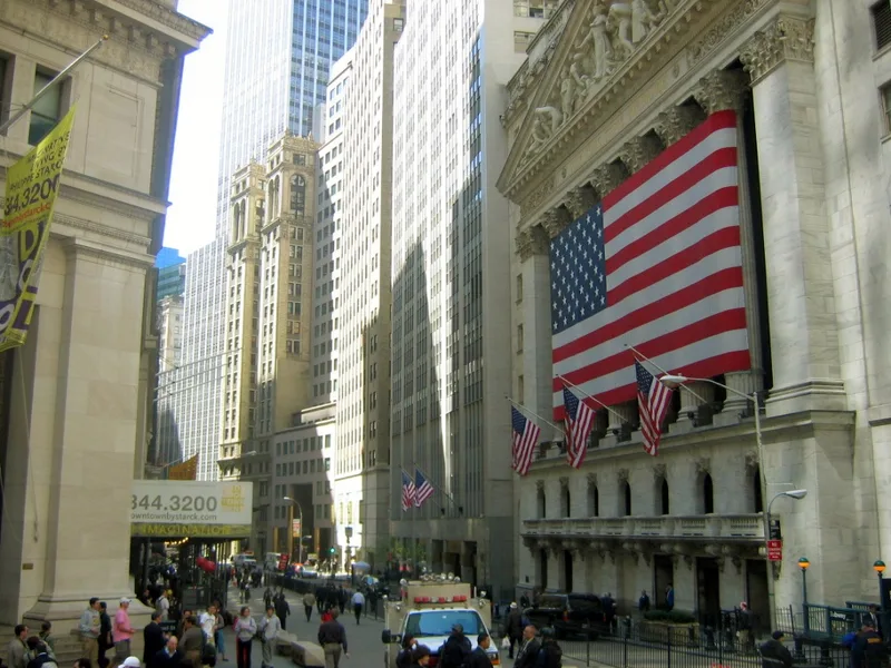
Occupying 36 blocks at the southern tip of Manhattan, this district forms the core of New York's financial center. Its narrow, curving streets follow the layout of Dutch Nieuw Amsterdam and its English successors, and are the only surviving artifact of that colonial period because the Great Fire of 1835 destroyed nearly everything else. The earliest buildings date from the late 1830s and 1840s, including Federal Hall, the Merchants Exchange and Trinity Church. Most of the 66 contributing buildings are office towers built between 1835 and 1932, many designed by leading firms as headquarters for major businesses. Neo-Classical, Neo-Renaissance, neo-Gothic, Art Deco and later International Style skyscrapers create the "canyons" of the financial district and its well-known skyline. Twenty-two properties within it are individually listed, and 29 buildings are New York City landmarks. Despite additions, new storefronts and residential conversions, the district retains strong historical and architectural integrity.
Significance in brief: The nomination argues the district is one of the most significant areas in the country, reflecting its history as a 17th-century Dutch colony, the nation's first capital, and the nation's financial center for two centuries. It holds one of the world's greatest collections of skyscrapers by prominent architects, and its colonial street plan is the only surviving artifact of Dutch Nieuw Amsterdam.
Machine-generated summary. This summary was generated by a language model from the official nomination document and has not been reviewed line by line by an editor. It may contain errors. Check the source document before relying on any detail. Source: nomination document (PDF) · National Archives catalog entry. NRHP reference 07000063, listed February 20, 2007. Summary generated October 2026 (model claude-sonnet-5-5, prompt v1.0-2026-10-29, confidence medium).
Key facts
| Address | Roughly bounded by Cedar St. and Maiden's Ln., Pearl St., Bridge and S. William St., and Greenwich St. and Trinity Pl., New York |
|---|---|
| County | Manhattan |
| Listed | February 20, 2007 |
| Reference number | 07000063 |
| Resource type | District |
| Architect / builder | Multiple, including Town & Davis, Isaiah Rogers, Richard Upjohn, Cass Gilbert, George B. Post, Trowbridge & Livingston, York & Sawyer, Ralph Walker of Voorhees, Gmelin & Walker, and Skidmore, Owings & Merrill |
| Architectural style | Greek Revival, Gothic Revival, Second Empire, Romanesque, Renaissance, Beaux Arts, Classical Revival, Skyscraper, Moderne, Art Deco, International |
| Areas of significance | Architecture, Commerce, Economics, Community Planning and Development, Politics/Government |
| Level of significance | National |
| Status (as stated in the nomination) | Buildings remain in commercial, government, religious and residential use; many have been altered or converted to residential use, but the district retains a high level of integrity. |
| Acreage | 63 |
| Coordinates | 40.70648, -74.01070 (NPS GIS) |
What listing means for this property
This is a historic district. Buildings within its boundary are either contributing (they add to the district's significance) or non-contributing. Owners of contributing income-producing buildings can claim the 20% federal rehabilitation tax credit; homeowners should look at state credits. National Register districts impose no design review by themselves; a local historic district ordinance, if one exists, does (the difference explained).
General information, not legal or tax advice. Rules change; confirm with your State Historic Preservation Office or a qualified adviser.
Sources and further reading
- National Park Service, National Register of Historic Places database (snapshot May 2026), reference 07000063.
- Nomination form (PDF, National Archives) — catalog entry
- Wikipedia article (used for cross-checking only; text not reproduced here)
- Wikidata Q7962614
- This listing as JSON
Last updated October 2026. Found an error? See the editorial policy for how to report it.