Williamsburg Cemetery

Why it's listed
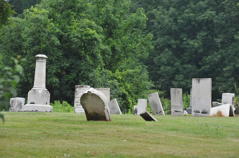
Tucked into farmland and second-growth forest off Abel Road in Groveland, this small cemetery is all that remains above ground of Williamsburg, the first village founded in the region by land agent Captain Charles Williamson in 1792. The village declined and eventually disappeared, but the burial ground survives, marked on an 1794 survey map. Its stones, dated from 1814 to about 1910, include obelisks, marble tablets, a coffin-shaped granite marker and a carved sheaf of wheat. The cemetery holds the graves of Charles Carroll and William Fitzhugh, early investors and settlers who were partners of Nathaniel Rochester, along with family members active in the courts, Congress and banking. James G. Birney, an abolitionist nominated for president by the Liberty Party in 1840 and 1844, is also buried here. An unadorned stone for "Mamma Rachael", presumed to be a Carroll family servant, adds to the story of early settlement.
Significance in brief: The nomination argues it is one of the earliest European-American settlement-period community cemeteries in western New York and the last above-ground remnant of the vanished village of Williamsburg. It also holds the graves of prominent Genesee Valley figures, including members of the Carroll and Fitzhugh families and abolitionist presidential candidate James G. Birney.
Machine-generated summary. This summary was generated by a language model from the official nomination document and has not been reviewed line by line by an editor. It may contain errors. Check the source document before relying on any detail. Source: nomination document (PDF) · National Archives catalog entry. NRHP reference 02001328, listed November 14, 2002. Summary generated October 2026 (model claude-sonnet-5-5, prompt v1.0-2026-10-29, confidence medium).
Key facts
| Address | Abel Rd., Hampton Corners |
|---|---|
| County | Livingston County |
| Listed | November 14, 2002 |
| Reference number | 02001328 |
| Resource type | Site |
| Period of significance | 1792-ca 1910 |
| Criteria |
|
| Areas of significance | Exploration/Settlement, Social History |
| Level of significance | Local |
| Status (as stated in the nomination) | The cemetery and its stones are described as in generally good repair, with an iron picket fence of early twentieth-century appearance. |
| Acreage | 0.7 |
| Coordinates | 42.74837, -77.83153 (NPS GIS) |
What listing means for this property
Sites (archaeological sites, battlefields, landscapes) are often listed with a restricted address to protect them from looting or disturbance. Listing is honorary for private owners; federal undertakings on or near the site go through Section 106 review, and state laws may protect burials and artefacts regardless of listing.
General information, not legal or tax advice. Rules change; confirm with your State Historic Preservation Office or a qualified adviser.
Sources and further reading
- National Park Service, National Register of Historic Places database (snapshot May 2026), reference 02001328.
- Nomination form (PDF, National Archives) — catalog entry
- Wikipedia article (used for cross-checking only; text not reproduced here)
- Wikidata Q8021158
- This listing as JSON
Last updated October 2026. Found an error? See the editorial policy for how to report it.