Farrier, Amasa, House
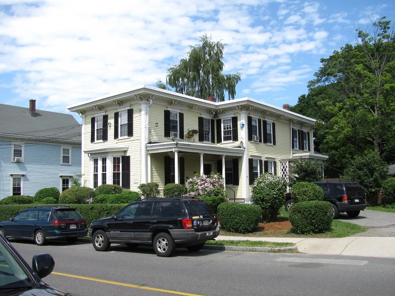

Why it's listed
Built around 1865 at 55 Central Street in Stoneham, this two-story Italianate villa was the family home of Amasa Farrier. It has an L-shaped plan with a one-story porch set in the angle, clapboard siding with wide cornerboards, and a nearly flat, overhanging roof carried on paired brackets. The foundation is brick, and the windows have heavy projecting caps and original six-over-six sash. The house is regarded as one of a small number of local examples that keep their original details. Farrier (1803-1883) came to Stoneham in 1838 and worked as its principal surveyor and landscape designer while holding several town offices. He subdivided land for homebuilding and designed the Stoneham Cemetery in 1844 and Lindenwood Cemetery in 1862, work that shows familiarity with the English landscape gardener John Claudius Loudon. A picturesque landscape design once flanked the side of the house. It was listed for its architecture and its link to Farrier.
Significance in brief: The nomination calls it an excellent local example of the Italianate style and one of a small number that keep their original details intact. It is also tied to Amasa Farrier (1803-1883), Stoneham's principal nineteenth-century surveyor and landscape designer, who laid out local cemeteries and subdivisions.
Machine-generated summary. This summary was generated by a language model from the official nomination document and has not been reviewed line by line by an editor. It may contain errors. Check the source document before relying on any detail. Source: nomination document (PDF) · National Archives catalog entry. NRHP reference 84002605, listed April 13, 1984. Summary generated October 2026 (model claude-sonnet-5-5, prompt v1.0-2026-10-29, confidence medium).
Key facts
| Address | 55 Central St., Stoneham |
|---|---|
| County | Middlesex County |
| Listed | April 13, 1984 |
| Reference number | 84002605 |
| Resource type | Building |
| Architectural style | Italianate |
| Criteria |
|
| Areas of significance | Community Planning and Development, Architecture |
| Level of significance | Local |
| Status (as stated in the nomination) | Form lists no major alterations and says the house has not been moved; original 6/6 sash survive. |
| Acreage | 0.2 |
| Coordinates | 42.48161, -71.09818 (NPS GIS) |
What listing means for this property
National Register listing is honorary for a privately owned home: it does not by itself restrict what an owner may do with their own money, and it does not require public access. Restrictions come from local landmark or historic-district ordinances, which are separate (how they differ).
Owner-occupied houses are not eligible for the 20% federal rehabilitation tax credit, which applies to income-producing buildings, but many states offer credits for homeowners. Listing also opens the door to preservation easements and to buying a plaque. Start with what listing means for homeowners, renovating a listed house and selling one.
General information, not legal or tax advice. Rules change; confirm with your State Historic Preservation Office or a qualified adviser.
Sources and further reading
- National Park Service, National Register of Historic Places database (snapshot May 2026), reference 84002605.
- Nomination form (PDF, National Archives) — catalog entry
- Wikipedia article (used for cross-checking only; text not reproduced here)
- Wikidata Q4740379
- This listing as JSON
Last updated October 2026. Found an error? See the editorial policy for how to report it.