Baldwin, Loammi, Mansion

Why it's listed
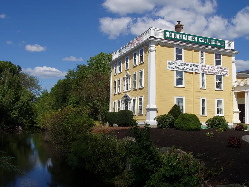
This three-story mansion in Woburn, Massachusetts, dates from about 1750 according to the Historic American Buildings Survey. It has imitation ashlar siding, a hipped roof with a monitor, a five-bay main facade, and giant Tuscan pilasters on high pedestals at the corners. The elaborate entrance and Palladian window above it appear to be later additions, and a two-story rear ell was added around 1820. The Baldwin family owned the land from 1661 to 1933. Col. Loammi Baldwin, a Revolutionary War officer, supervised construction of the Middlesex Canal, completed in 1803, and gave his name to the Baldwin apple after finding the original tree while surveying. He was born and died in the house. His son Loammi Baldwin Jr., considered the father of American civil engineering, also lived there. Threatened with demolition, the house was moved about 800 feet from Elm Street to a site beside the canal off Alfred Street, where it was intended to become a museum after restoration.
Significance in brief: The Baldwin family owned the property from 1661 to 1933. Col. Loammi Baldwin, builder of the Middlesex Canal and discoverer of the Baldwin apple, was born and died in the house, and his son Loammi Baldwin Jr., called the father of American civil engineering, also lived there. It is also described as one of the best examples of Federal architecture in the locality.
Machine-generated summary. This summary was generated by a language model from the official nomination document and has not been reviewed line by line by an editor. It may contain errors. Check the source document before relying on any detail. Source: nomination document (PDF) · National Archives catalog entry. NRHP reference 71000090, listed October 7, 1971. Summary generated October 2026 (model claude-sonnet-5-5, prompt v1.0-2026-10-29, confidence medium).
Key facts
| Address | 2 Alfred St., Woburn |
|---|---|
| County | Middlesex County |
| Listed | October 7, 1971 |
| Reference number | 71000090 |
| Resource type | Building |
| Period of significance | 18th and 19th centuries (specific date c.1750) |
| Architectural style | Federal |
| Areas of significance | Military, Engineering, Politics/Government, Architecture, Agriculture |
| Level of significance | National |
| Status (as stated in the nomination) | Moved about 800 feet to Alfred Street because it was threatened with demolition; the later form lists it as unoccupied, with preservation work in progress and a planned museum use after restoration. |
| Acreage | 0.9 |
| Coordinates | 42.50230, -71.15754 (NPS GIS) |
What listing means for this property
National Register listing is honorary for a privately owned home: it does not by itself restrict what an owner may do with their own money, and it does not require public access. Restrictions come from local landmark or historic-district ordinances, which are separate (how they differ).
Owner-occupied houses are not eligible for the 20% federal rehabilitation tax credit, which applies to income-producing buildings, but many states offer credits for homeowners. Listing also opens the door to preservation easements and to buying a plaque. Start with what listing means for homeowners, renovating a listed house and selling one.
Noted as vacant in the nomination. Nomination documents can be decades old; current status may differ. If you are considering buying an empty listed property, read the due-diligence checklist.
General information, not legal or tax advice. Rules change; confirm with your State Historic Preservation Office or a qualified adviser.
Sources and further reading
- National Park Service, National Register of Historic Places database (snapshot May 2026), reference 71000090.
- Nomination form (PDF, National Archives) — catalog entry
- Wikipedia article (used for cross-checking only; text not reproduced here)
- Wikidata Q4850567
- This listing as JSON
Last updated October 2026. Found an error? See the editorial policy for how to report it.