Lynn Woods Historic District

Why it's listed
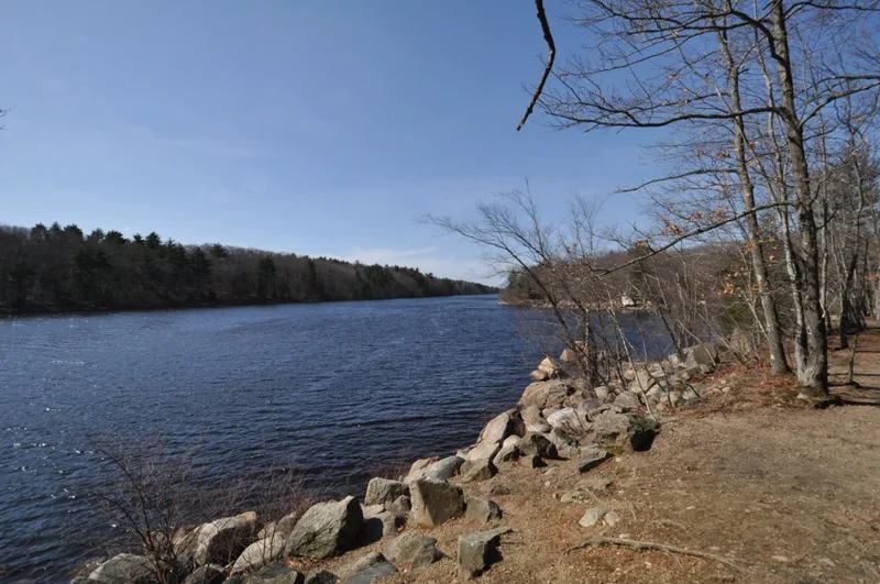
Lynn Woods is a 2,200-acre tract of woodland, swamp and granite ridges in northern Lynn, Massachusetts, set between the Walden Pond and Breed's Pond reservoirs. Once part of the town's 17th-century common land, it was bought in stages from 1882 to 1892 by the Trustees of the Free Public Forest and the City of Lynn for use as a public forest and water supply. Frederick Law Olmsted advised in 1889 that the woods be left as rugged forest rather than a formal park, and an 1892 plan by John T. McClintock set out carriage roads and trails. The district holds colonial stone walls, the Wolf Pits, Penny Bridge, the Dungeon Rock Tunnel dug by the Marble family from 1852 to 1880, brick pump houses, and 1930s WPA structures including the Happy Valley Club House and Burrill Hill tower. Prehistoric sites are also documented. The nomination cites its early public parkland planning as the main reason for listing.
Significance in brief: The nomination argues the district was an early and significant regional landscape planning innovation, creating a natural public forest and water reservoir area before the Metropolitan Park Commission was formed in 1893. It follows Frederick Law Olmsted's 1889 recommendation to keep the woods 'rugged and wild.' It also preserves colonial land divisions, the Dungeon Rock Tunnel, mid-19th-century Exploring Circle trails, reservoir works and WPA-era park structures, plus prehistoric archaeological potential.
Machine-generated summary. This summary was generated by a language model from the official nomination document and has not been reviewed line by line by an editor. It may contain errors. Check the source document before relying on any detail. Source: nomination document (PDF) · National Archives catalog entry. NRHP reference 96000951, listed September 6, 1996. Summary generated October 2026 (model claude-sonnet-5-5, prompt v1.0-2026-10-29, confidence medium).
Key facts
| Address | Roughly bounded by Lynnfield St., Bow Ridge, Great Woods Rd., Parkland Ave., Walnut St., Saugus Line, Lynn |
|---|---|
| County | Essex County |
| Listed | September 6, 1996 |
| Reference number | 96000951 |
| Resource type | District |
| Period of significance | 17th century to 1946 (Plantation Period through Early Modern Period; most significant development 1890-1915) |
| Architect / builder | Frederick Law Olmsted (consulting survey, 1889); John T. McClintock (Park Engineer, 1892 plan); WPA Lynn staff; Marble Family (Dungeon Rock Tunnel) |
| Architectural style | Rustic Craftsman (WPA park buildings); Craftsman Bungalow; Queen Anne-Panel Brick pump houses |
| Areas of significance | Social History, Landscape Architecture, Conservation, Historic - Aboriginal |
| Level of significance | Local |
| Status (as stated in the nomination) | Deterioration from deferred maintenance since World War II is noted; the observation towers are decaying and the Morrissey House is used for storage and office space, while the golf course and club house have been maintained. The bandstand and picnic grove are described as abandoned. |
| Acreage | 2200 |
| Coordinates | 42.48898, -70.98692 (NPS GIS) |
What listing means for this property
This is a historic district. Buildings within its boundary are either contributing (they add to the district's significance) or non-contributing. Owners of contributing income-producing buildings can claim the 20% federal rehabilitation tax credit; homeowners should look at state credits. National Register districts impose no design review by themselves; a local historic district ordinance, if one exists, does (the difference explained).
General information, not legal or tax advice. Rules change; confirm with your State Historic Preservation Office or a qualified adviser.
Sources and further reading
- National Park Service, National Register of Historic Places database (snapshot May 2026), reference 96000951.
- Nomination form (PDF, National Archives) — catalog entry
- Wikipedia article (used for cross-checking only; text not reproduced here)
- Wikidata Q14715688
- This listing as JSON
Last updated October 2026. Found an error? See the editorial policy for how to report it.