Ruggles Park

Why it's listed
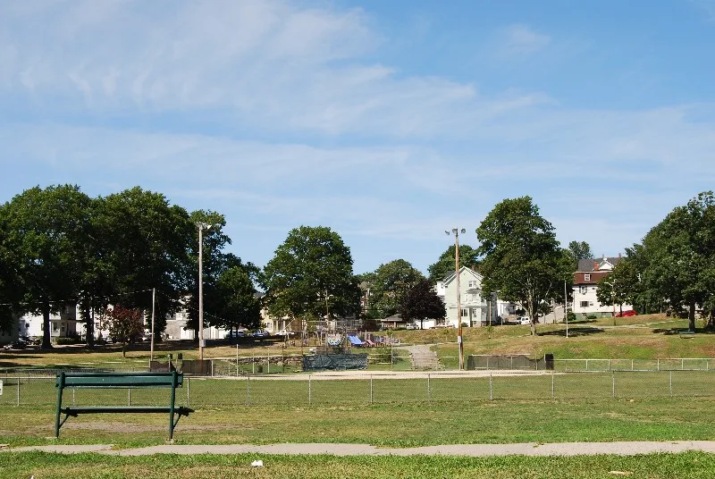
Ruggles Park is a roughly 9-acre public park on Seabury Street in north-central Fall River, set within a dense working-class neighborhood. The city bought the land in 1868, when it was part of the old Rodman farm and known as Ruggles Grove, and the park originally covered 15 acres. Its main design feature is a high granite retaining wall separating the raised northeast corner from the rest of the grounds. Today the only large flat open space is a ballfield, and plantings are sparse. Tenement houses overlook the park from above the wall, and nearby streets contain 19th-century houses, including Second Empire and Italianate examples. The park was listed as one of the city's two oldest, serving as recreation space for mill workers. In 1901 the city created a Park Commission, which hired Olmsted Brothers, the firm of John C. Olmsted and Frederick Law Olmsted, Jr. Their 1903 plan and planting lists survive in the Parks Department files.
Significance in brief: The nomination presents it as one of the two oldest parks in Fall River and as a late 19th-century recreational park for the city's working population. It is also associated with the nationally known landscape architecture firm Olmsted Brothers, which drew up improvement plans in 1903. The form says it meets criteria A and C.
Machine-generated summary. This summary was generated by a language model from the official nomination document and has not been reviewed line by line by an editor. It may contain errors. Check the source document before relying on any detail. Source: nomination document (PDF) · National Archives catalog entry. NRHP reference 83000711, listed February 16, 1983. Summary generated October 2026 (model claude-sonnet-5-5, prompt v1.0-2026-10-29, confidence medium).
Key facts
| Address | Bounded by Seabury, Robeson, Pine, and Locust Sts., Fall River |
|---|---|
| County | Bristol County |
| Listed | February 16, 1983 |
| Reference number | 83000711 |
| Resource type | Site |
| Period of significance | 1868-present |
| Architect / builder | Olmsted Brothers (John C. Olmsted and Frederick Law Olmsted, Jr.), landscape architects of the 1903 improvement plans |
| Criteria |
|
| Areas of significance | Landscape Architecture, Architecture |
| Level of significance | State |
| Status (as stated in the nomination) | The only large flat open space is now a ballfield, and plantings are described as relatively sparse. |
| Acreage | 8.2 |
| Coordinates | 41.70397, -71.14566 (NPS GIS) |
What listing means for this property
Sites (archaeological sites, battlefields, landscapes) are often listed with a restricted address to protect them from looting or disturbance. Listing is honorary for private owners; federal undertakings on or near the site go through Section 106 review, and state laws may protect burials and artefacts regardless of listing.
General information, not legal or tax advice. Rules change; confirm with your State Historic Preservation Office or a qualified adviser.
Sources and further reading
- National Park Service, National Register of Historic Places database (snapshot May 2026), reference 83000711.
- Nomination form (PDF, National Archives) — catalog entry
- Wikipedia article (used for cross-checking only; text not reproduced here)
- Wikidata Q7378584
- This listing as JSON
Last updated October 2026. Found an error? See the editorial policy for how to report it.