New Bedford Historic District
Also known as: see also: New Bedford Whaling National Historical Park

Why it's listed
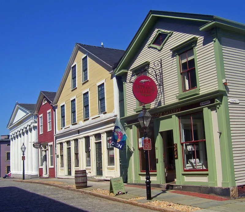
This 19.6-acre district in downtown New Bedford, Massachusetts, preserves part of the commercial core of a leading whaling port. It covers eleven blocks and part of a twelfth, with about 20 notable buildings, most built between 1810 and 1855. They include the granite Custom House designed by Robert Mills, the Greek Revival Mechanics and Merchants Banks and the Institution for Savings, both by Russell Warren, the Samuel Rodman House and Candlehouse, the Seamen's Bethel, the Mariner's Home, and brick or stone warehouses. New Bedford grew as a whaling port from the 1760s, passed Nantucket by 1840, and peaked in 1857, when it owned half the nation's whaling ships. Whaling then declined as petroleum rose, and the last voyage ended in 1925. Modern intrusions, including a gas station and a large parking facility, and altered storefronts affect the area. A local historic district ordinance adopted in 1971 aims to protect its character and encourage rehabilitation.
Significance in brief: The district is presented as a good example of the commercial center of a major New England whaling seaport between 1810 and 1855. It keeps about 20 historic buildings, including the Custom House, banks and warehouses, several designed by architect Russell Warren. New Bedford became the nation's leading whaling port, and the district reflects that era.
Machine-generated summary. This summary was generated by a language model from the official nomination document and has not been reviewed line by line by an editor. It may contain errors. Check the source document before relying on any detail. Source: nomination document (PDF) · National Archives catalog entry. NRHP reference 66000773, listed November 13, 1966. Summary generated October 2026 (model claude-sonnet-5-5, prompt v1.0-2026-10-29, confidence medium).
Key facts
| Address | Bounded by Front St. on E, Elm St. on N, Acushnet Ave. on W, and Commercial St. on S, New Bedford |
|---|---|
| County | Bristol County |
| Listed | November 13, 1966 |
| Reference number | 66000773 |
| Resource type | District |
| Period of significance | c. 1790, 1810-1855 |
| Architect / builder | Russell Warren and others; Robert Mills (Custom House, built by Seth H. Ingalls) |
| Architectural style | Federal, Greek Revival and Renaissance Revival commercial and public buildings |
| Areas of significance | Industry, Commerce |
| Level of significance | National |
| National Historic Landmark | Yes, designated November 13, 1966 |
| Status (as stated in the nomination) | Condition marked good; some intrusions such as a gas station and a parking structure and lot, and altered signage and storefronts on some buildings. Many buildings have new commercial uses. |
| Acreage | 19.6 |
| Coordinates | 41.63583, -70.92402 (NPS GIS) |
What listing means for this property
This is a historic district. Buildings within its boundary are either contributing (they add to the district's significance) or non-contributing. Owners of contributing income-producing buildings can claim the 20% federal rehabilitation tax credit; homeowners should look at state credits. National Register districts impose no design review by themselves; a local historic district ordinance, if one exists, does (the difference explained).
General information, not legal or tax advice. Rules change; confirm with your State Historic Preservation Office or a qualified adviser.
Sources and further reading
- National Park Service, National Register of Historic Places database (snapshot May 2026), reference 66000773.
- Nomination form (PDF, National Archives) — catalog entry
- Wikipedia article (used for cross-checking only; text not reproduced here)
- Wikidata Q1982412
- This listing as JSON
Last updated October 2026. Found an error? See the editorial policy for how to report it.