Kennedy Park

Why it's listed
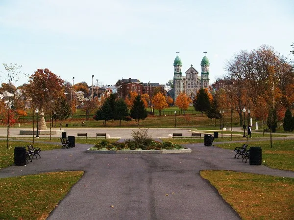
Kennedy Park is a 57-acre public park in southwestern Fall River, Massachusetts, set within a largely middle and working class residential neighborhood. Established in 1868 as South Park, it is the city's largest park and one of its two oldest. Fall River hired Olmsted, Vaux & Co. to plan it, and an 1871 drawing shows an open parade and ballfield on the upper section with a densely planted natural area below. In 1901 a new Park Commission engaged Olmsted Brothers, whose 1903 plan included a wading pool, shelter, bandstand, parade area and look-out shelter. Surviving features include a Colonial Revival shelter, an early bandstand, the fieldstone base of a burned look-out shelter, perimeter retaining walls and interior paths. Seven statues and monuments have been added, notably a 1951 bronze World War II soldier by Aristide Cianfarani. Hurricanes, vandalism and recreational facilities such as tennis courts have altered the original design. The park was listed for its civic importance and its Olmsted connections.
Significance in brief: The park is argued to be significant as a major civic improvement of Fall River's late 19th century expansion, as the city's largest and one of its oldest parks serving a working class neighborhood, and for its association with the landscape architecture firms Olmsted, Vaux & Co. and Olmsted Brothers. The form states it meets criteria A and C.
Machine-generated summary. This summary was generated by a language model from the official nomination document and has not been reviewed line by line by an editor. It may contain errors. Check the source document before relying on any detail. Source: nomination document (PDF) · National Archives catalog entry. NRHP reference 83000686, listed February 16, 1983. Summary generated October 2026 (model claude-sonnet-5-5, prompt v1.0-2026-10-29, confidence medium).
Key facts
| Address | Bounded by S. Main St., Bradford Ave., Middle, and Bay Sts., Fall River |
|---|---|
| County | Bristol County |
| Listed | February 16, 1983 |
| Reference number | 83000686 |
| Resource type | Site |
| Period of significance | 1868-present |
| Architect / builder | Olmsted, Vaux & Co. (1871 plan); Olmsted Brothers (1903 plan) |
| Architectural style | Landscape park with a Colonial Revival shelter and the base of a Shingle Style look-out shelter |
| Criteria |
|
| Areas of significance | Landscape Architecture, Entertainment/Recreation, Architecture |
| Level of significance | State |
| Status (as stated in the nomination) | Early features remaining include a Colonial Revival shelter, a bandstand, a fieldstone retaining wall and pathways; the Shingle Style look-out shelter burned, leaving its fieldstone base. Hurricane damage, vandalism and limited planting funds have affected the trees and landscaping. |
| Acreage | 57.1 |
| Coordinates | 41.69462, -71.16669 (NPS GIS) |
What listing means for this property
Sites (archaeological sites, battlefields, landscapes) are often listed with a restricted address to protect them from looting or disturbance. Listing is honorary for private owners; federal undertakings on or near the site go through Section 106 review, and state laws may protect burials and artefacts regardless of listing.
General information, not legal or tax advice. Rules change; confirm with your State Historic Preservation Office or a qualified adviser.
Sources and further reading
- National Park Service, National Register of Historic Places database (snapshot May 2026), reference 83000686.
- Nomination form (PDF, National Archives) — catalog entry
- Wikipedia article (used for cross-checking only; text not reproduced here)
- Wikidata Q6389665
- This listing as JSON
Last updated October 2026. Found an error? See the editorial policy for how to report it.