Old Higgins Farm Windmill

Why it's listed
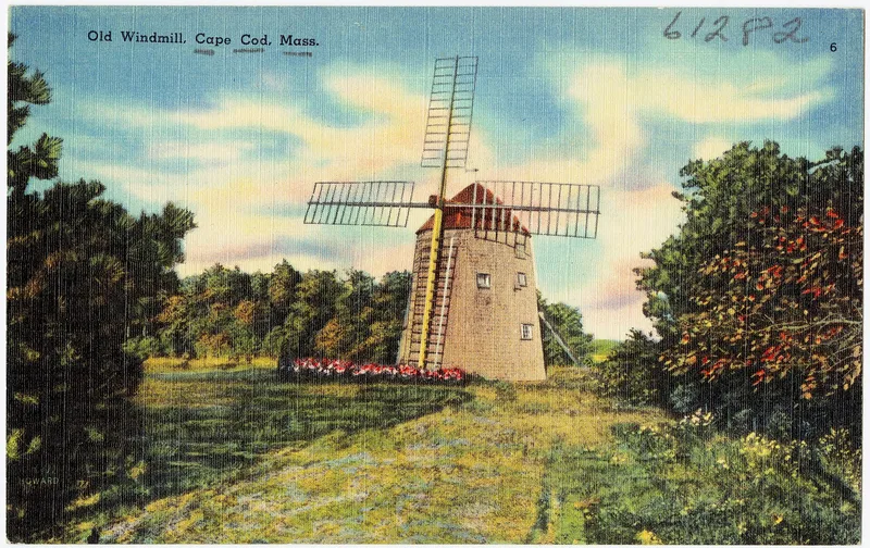
This windmill in Brewster, Massachusetts, is a 30-foot shingled structure with a fixed octagonal base 20 feet across and a revolving cap framed with curved members like a ship's hull. Inside, three levels hold wooden gears, a bread wheel, grindstones and a corn cob cracker. Carvings reminiscent of scrimshaw, together with the boat-like construction, led locals to believe ship builders made it, though this was never confirmed. Records place a mill on Crosby land by 1795, and by 1845 it was the only windmill in Brewster. It was moved several times, around 1890 to a nearby estate where it served as a golf course clubhouse, and again in 1974 after being donated to the Brewster Historical Society. It is valued as one of the few surviving Cape Cod windmills of its type, which ground corn, the region's main 19th-century export crop. About 85 percent of the structure is original, and restoration is under way.
Significance in brief: It is one of the few remaining Cape Cod windmills of a type once numerous, and the only surviving one in Brewster. Its wooden machinery is almost entirely intact, and its interior carvings resemble scrimshaw. It ground the corn that was Cape Cod's main export crop in the 19th century.
Machine-generated summary. This summary was generated by a language model from the official nomination document and has not been reviewed line by line by an editor. It may contain errors. Check the source document before relying on any detail. Source: nomination document (PDF) · National Archives catalog entry. NRHP reference 75000240, listed June 10, 1975. Summary generated October 2026 (model claude-sonnet-5-5, prompt v1.0-2026-10-29, confidence medium).
Key facts
| Address | 51 Drummer Boy Rd., Brewster |
|---|---|
| County | Barnstable County |
| Listed | June 10, 1975 |
| Reference number | 75000240 |
| Resource type | Structure |
| Areas of significance | Engineering, Agriculture |
| Level of significance | Local |
| Status (as stated in the nomination) | Moved in December 1974 to a nearby site and under restoration to working condition; condition listed as fair, with sails lost and tail pole rotted. Planned for public educational and recreational use. |
| Acreage | 0.9 |
| Coordinates | 41.75224, -70.12069 (NPS GIS) |
What listing means for this property
National Register listing is honorary for a privately owned home: it does not by itself restrict what an owner may do with their own money, and it does not require public access. Restrictions come from local landmark or historic-district ordinances, which are separate (how they differ).
Owner-occupied houses are not eligible for the 20% federal rehabilitation tax credit, which applies to income-producing buildings, but many states offer credits for homeowners. Listing also opens the door to preservation easements and to buying a plaque. Start with what listing means for homeowners, renovating a listed house and selling one.
General information, not legal or tax advice. Rules change; confirm with your State Historic Preservation Office or a qualified adviser.
Sources and further reading
- National Park Service, National Register of Historic Places database (snapshot May 2026), reference 75000240.
- Nomination form (PDF, National Archives) — catalog entry
- Wikipedia article (used for cross-checking only; text not reproduced here)
- Wikidata Q7084205
- This listing as JSON
Last updated October 2026. Found an error? See the editorial policy for how to report it.