Shockoe Valley and Tobacco Row Historic District (Additional Documentation)

Why it's listed
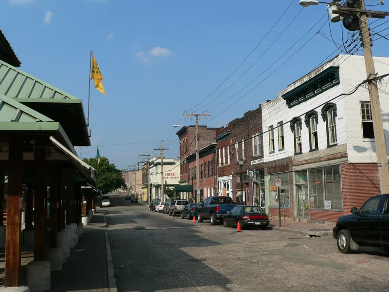
Shockoe Valley and Tobacco Row is a 129-acre section of downtown Richmond, Virginia, running from the James River and Richmond Dock up toward Church and Union hills. It holds over 500 buildings, including tobacco factories and warehouses along East Cary Street, cast-iron storefronts on East Main Street, the Farmers' Market area, railroad depots, viaducts, and a small residential block of town houses on North 19th Street. The area marks the site of Richmond's earliest settlement, laid out in 1737 and later shaped by canal and railroad transportation. Tobacco manufacturing made the city a leading commercial center by 1860, and the industry drove its recovery after the Civil War. The district was listed for this record of commerce and for its range of architecture, from Federal houses and the Old Stone House to Greek Revival, Italianate, and industrial buildings. Demolition, parking lots, and expressway construction have damaged parts of its edges, while revitalization efforts continue.
Significance in brief: The district covers the area of Richmond's earliest residential, commercial, and manufacturing activity and reflects the city's growth from village to metropolis. It is tied to tobacco manufacturing, canal and railroad transportation, and the Civil War era. It is also significant for the stylistic diversity of roughly 530 buildings, from Federal through 20th-century industrial vernacular.
Machine-generated summary. This summary was generated by a language model from the official nomination document and has not been reviewed line by line by an editor. It may contain errors. Check the source document before relying on any detail. Source: nomination document (PDF) · National Archives catalog entry. NRHP reference 83003308, listed February 24, 1983. Summary generated October 2026 (model claude-sonnet-5-5, prompt v1.0-2026-10-29, confidence medium).
Key facts
| Address | Roughly bounded by Dock, 15th, Clay, Franklin, and Peach Sts., Richmond (Independent City) |
|---|---|
| County | Richmond (city and county) |
| Listed | February 24, 1983 |
| Reference number | 83003308 |
| Resource type | District |
| Architectural style | Federal, Greek Revival, Italianate, Second Empire, Romanesque Revival, Classical Revival, Colonial Revival, and 19th- and 20th-century commercial and industrial vernacular |
| Areas of significance | Industry, Commerce, Military, Transportation, Literature, Exploration/Settlement, Politics/Government, Architecture, Community Planning and Development |
| Level of significance | State |
| Status (as stated in the nomination) | Many buildings are in disrepair and some 19th-century buildings have been lost, leaving vacant land and parking lots. Revitalization efforts are underway around the Farmers' Market and Tobacco Row, and the district is mixed in use, mainly commercial and industrial. |
| Acreage | 129 |
| Within district | St. John's Church Historic District |
| Coordinates | 37.53021, -77.42332 (NPS GIS) |
What listing means for this property
This is a historic district. Buildings within its boundary are either contributing (they add to the district's significance) or non-contributing. Owners of contributing income-producing buildings can claim the 20% federal rehabilitation tax credit; homeowners should look at state credits. National Register districts impose no design review by themselves; a local historic district ordinance, if one exists, does (the difference explained).
General information, not legal or tax advice. Rules change; confirm with your State Historic Preservation Office or a qualified adviser.
Sources and further reading
- National Park Service, National Register of Historic Places database (snapshot May 2026), reference 83003308.
- Nomination form (PDF, National Archives) — catalog entry
- Wikipedia article (used for cross-checking only; text not reproduced here)
- Wikidata Q18158035
- This listing as JSON
Last updated October 2026. Found an error? See the editorial policy for how to report it.