Galveston Seawall

Why it's listed
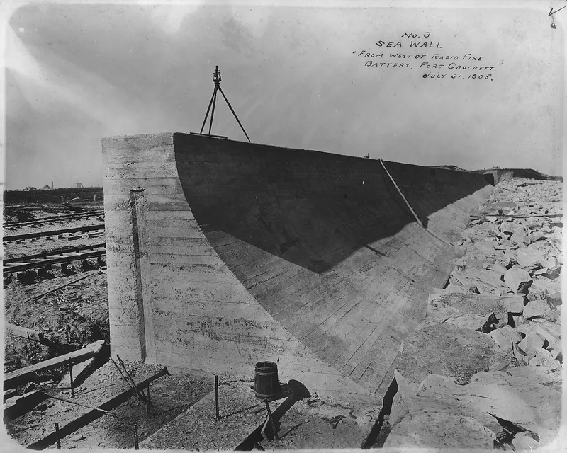
Galveston's seawall is a curved concrete barrier along Seawall Boulevard, built between 1902 and 1904 after the hurricane of September 8, 1900 killed about 6,000 of the city's 38,000 residents and destroyed 3,600 homes. Engineers H. M. Robert, Alfred Noble and H. C. Ripley designed it, and J. M. O'Rourke and Company built it. The first segment ran 17,593 feet, stood 17 feet high, and measured 16 feet wide at the base and 5 feet at the top. It rests on wooden piles and has a concave seaward face that turns waves back toward the Gulf, with granite riprap at its toe. The Corps of Engineers extended it in 1918, and later work brought it to more than ten miles. A grade-raising project lifted the city, in places by as much as 20 feet, to provide solid backing for the wall. The wall helped protect the city during the 1915 storm.
Significance in brief: The seawall is presented as a massive engineering effort by a community responding to the 1900 hurricane, which killed about 6,000 people. It protected Galveston in the 1915 storm and allowed the city to grow. It was paired with a grade-raising project that lifted much of the city by up to 20 feet.
Machine-generated summary. This summary was generated by a language model from the official nomination document and has not been reviewed line by line by an editor. It may contain errors. Check the source document before relying on any detail. Source: nomination document (PDF) · National Archives catalog entry. NRHP reference 77001443, listed August 18, 1977. Summary generated October 2026 (model claude-sonnet-5-5, prompt v1.0-2026-10-29, confidence high).
Key facts
| Address | Seawall Blvd., Galveston |
|---|---|
| County | Galveston County |
| Listed | August 18, 1977 |
| Reference number | 77001443 |
| Resource type | Structure |
| Period of significance | 1900- (specific dates October 1902-July 1904) |
| Architect / builder | J. M. 'Rourke & Co. (J. M. O'Rourke and Company); designed by Gen. H. M. Robert, Alfred Noble and H. C. Ripley; George Boschke, chief engineer for the city |
| Areas of significance | Community Planning and Development, Conservation, Engineering, Politics/Government |
| Level of significance | National |
| Status (as stated in the nomination) | Condition listed as excellent and altered; occupied; owned by the City of Galveston. The wall has been extended several times and is now over 10 miles long. |
| Acreage | 8 |
| Coordinates | 29.30274, -94.77440 (NPS GIS) |
What listing means for this property
National Register listing is honorary: it recognises significance and does not restrict what a private owner may do without federal money or permits. It unlocks the 20% federal rehabilitation tax credit for income-producing buildings, state credits in many states, and Section 106 review when federal agencies are involved. See what listing means in practice.
General information, not legal or tax advice. Rules change; confirm with your State Historic Preservation Office or a qualified adviser.
Sources and further reading
- National Park Service, National Register of Historic Places database (snapshot May 2026), reference 77001443.
- Nomination form (PDF, National Archives) — catalog entry
- Wikipedia article (used for cross-checking only; text not reproduced here)
- Wikidata Q5519430
- This listing as JSON
Last updated October 2026. Found an error? See the editorial policy for how to report it.