Franklin Square

Why it's listed
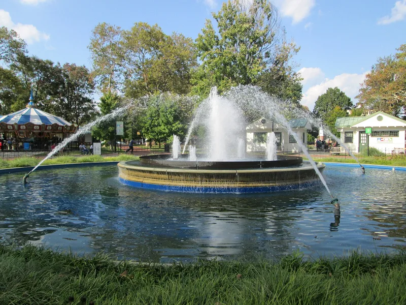
Franklin Square is an open green space in central Philadelphia, one of the four public squares laid out in the city's original plan. It was first levelled, planted and enclosed in 1815, after serving as an open common. In the 1830s it had an iron fence and a central fountain with forty water jets. Over the years it was leased for pasturage and cattle markets, served as a drilling ground during the War of 1812, and held a powder house during the Revolutionary War. In 1741 Governor Thomas Penn leased part of the square to the German Reformed Church for a burying ground. A long legal dispute followed over the Penn warrant, and in 1835 the State Supreme Court declared the warrant illegal and the church vacated the site. Today the square is hemmed in by highways and the Benjamin Franklin Bridge approaches, and it remains a rare green refuge for nearby residents and visitors.
Significance in brief: The nomination treats the square as one of the four original public squares of Philadelphia, with a long history of use from common land to burial ground and public park. Its listing reflects that history, including the 1835 court ruling that ended the German Reformed Church's burial use and the square's role in the city's planned layout.
Machine-generated summary. This summary was generated by a language model from the official nomination document and has not been reviewed line by line by an editor. It may contain errors. Check the source document before relying on any detail. Source: nomination document (PDF) · National Archives catalog entry. NRHP reference 81000556, listed September 14, 1981. Summary generated October 2026 (model claude-haiku-5-5, prompt v1.1-2026-10-29, confidence high).
Key facts
| Address | Race and 6th Sts., Philadelphia |
|---|---|
| County | Philadelphia |
| Listed | September 14, 1981 |
| Reference number | 81000556 |
| Resource type | Structure |
| Areas of significance | Community Planning and Development, Landscape Architecture, Art, Conservation |
| Level of significance | State |
| Status (as stated in the nomination) | Surrounded by highways and a subway stop at the southwest corner; the nomination notes the square is somewhat isolated but may see renewed interest from nearby residential development. |
| Acreage | 7.9 |
| Coordinates | 39.95562, -75.15041 (NPS GIS) |
What listing means for this property
National Register listing is honorary: it recognises significance and does not restrict what a private owner may do without federal money or permits. It unlocks the 20% federal rehabilitation tax credit for income-producing buildings, state credits in many states, and Section 106 review when federal agencies are involved. See what listing means in practice.
General information, not legal or tax advice. Rules change; confirm with your State Historic Preservation Office or a qualified adviser.
Sources and further reading
- National Park Service, National Register of Historic Places database (snapshot May 2026), reference 81000556.
- Nomination form (PDF, National Archives) — catalog entry
- Wikipedia article (used for cross-checking only; text not reproduced here)
- Wikidata Q5491849
- This listing as JSON
Last updated October 2026. Found an error? See the editorial policy for how to report it.