Bridge in City of Wilkes-Barre

Why it's listed
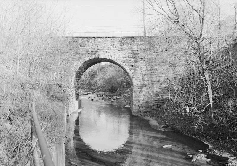
A single-span stone arch bridge over Mill Creek on LR 5 in the City of Wilkes-Barre, Luzerne County, Pennsylvania, located in the business district. Its arch is built of roughly squared coursed stone with voussoirs of rock-faced ashlar, and stone projections at the springline mark where the centering was attached during construction. The deck has simple iron railings on its parapet walls. The span measures 39 feet over the creek, and the bridge's nominated area is a rectangle of about 75 by 25 feet, including only the superstructure and substructure. The span rises from massive abutments, a feature the nomination describes as requiring exceptional engineering attention to carry heavy loads. Because of this structural approach and its span length relative to other bridges in its group, it was listed for its engineering significance. The construction date is not known from local records; state staff provided an approximate range of 1850 to 1900 at the time of listing.
Significance in brief: The nomination argues the bridge is significant for engineering. Its single span of about 39 feet is described as exceptionally high for the group, springing from massive abutments, which the nomination says required special engineering to carry heavy loads. It is one of the bridges in the multiple-resource group of Commonwealth-owned highway bridges.
Machine-generated summary. This summary was generated by a language model from the official nomination document and has not been reviewed line by line by an editor. It may contain errors. Check the source document before relying on any detail. Source: nomination document (PDF) · National Archives catalog entry. NRHP reference 88000828, listed June 22, 1988. Summary generated October 2026 (model claude-haiku-5-5, prompt v1.1-2026-10-29, confidence medium).
Key facts
| Address | LR 5 over Mill Creek, Wilkes-Barre |
|---|---|
| County | Luzerne County |
| Listed | June 22, 1988 |
| Reference number | 88000828 |
| Resource type | Structure |
| Areas of significance | Engineering |
| Level of significance | State |
| Acreage | 0.9 |
| Coordinates | 41.26017, -75.86687 (NPS GIS) |
What listing means for this property
For a publicly owned building or structure, listing mainly matters when federal funds, permits or licences are involved: projects then go through Section 106 review so effects on the property are considered. Listing also strengthens applications for preservation grants and, for leased income-producing uses, can enable the federal rehabilitation tax credit.
General information, not legal or tax advice. Rules change; confirm with your State Historic Preservation Office or a qualified adviser.
Sources and further reading
- National Park Service, National Register of Historic Places database (snapshot May 2026), reference 88000828.
- Nomination form (PDF, National Archives) — catalog entry
- Wikipedia article (used for cross-checking only; text not reproduced here)
- Wikidata Q4966344
- This listing as JSON
Last updated October 2026. Found an error? See the editorial policy for how to report it.