Burnside Plantation
Also known as: Burnside, James, Plantation; Lerch Farm

Why it's listed
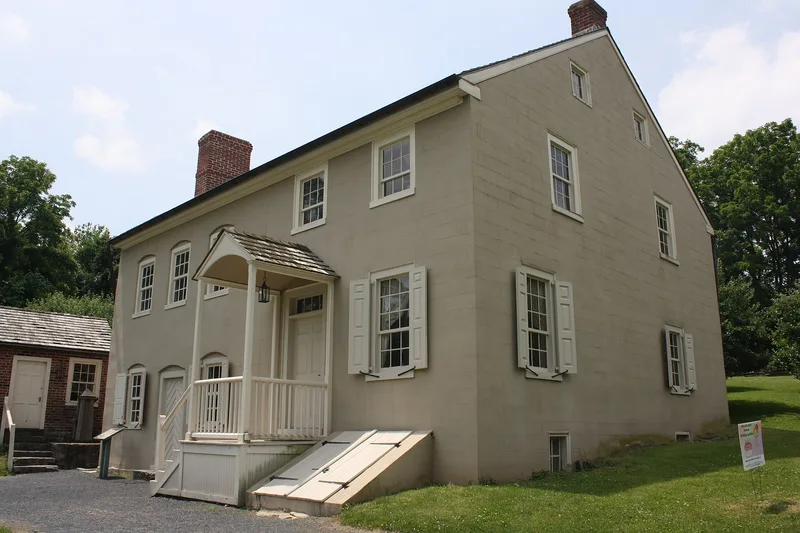
Burnside Plantation is a farmstead on the west bank of Monocacy Creek in Bethlehem, anchored by a two-story stone farmhouse whose south section was begun in 1748 by James Burnside, a former Irish-born Moravian who had settled in Savannah and then Bethlehem. The house was enlarged with a two-bay stone addition in 1816-1818, and later received a summer kitchen and cool cellar. Around it stand a wagon shed, a corn crib, and the stone foundation of an 1841-1842 Swiss-style bank barn. The property was leased as one of the Moravian Church's Bethlehem Plantations until 1845 and then sold to private owners. Its importance lies in the rare survival of Moravian lease, tax and map records that document how the house and farm changed over roughly a century, and in the mix of old hand-labour methods and newer horse-powered equipment seen on the site.
Significance in brief: The nomination argues the farm is an important example of Pennsylvania German architecture and of Moravian Plantation-system farming in Bethlehem. The house shows changes in style from the mid-eighteenth to mid-nineteenth century, and the Moravian Archives hold unusually complete written records of its construction and tenancy.
Machine-generated summary. This summary was generated by a language model from the official nomination document and has not been reviewed line by line by an editor. It may contain errors. Check the source document before relying on any detail. Source: nomination document (PDF) · National Archives catalog entry. NRHP reference 90000705, listed May 2, 1990. Summary generated October 2026 (model claude-haiku-5-5, prompt v1.1-2026-10-29, confidence high).
Key facts
| Address | Schoenersville Rd., 2 mi. SE of jct. with Easton Ave., Bethlehem |
|---|---|
| County | Lehigh County |
| Listed | May 2, 1990 |
| Reference number | 90000705 |
| Resource type | Building |
| Period of significance | 1748-1848 |
| Architectural style | Vernacular Germanic; Federal |
| Criteria |
|
| Areas of significance | Agriculture, Architecture |
| Level of significance | Local |
| Acreage | 6.5 |
| Within district | Lehigh Canal; Allentown to Hopeville Section |
| Coordinates | 40.63094, -75.38900 (NPS GIS) |
What listing means for this property
National Register listing is honorary for a privately owned home: it does not by itself restrict what an owner may do with their own money, and it does not require public access. Restrictions come from local landmark or historic-district ordinances, which are separate (how they differ).
Owner-occupied houses are not eligible for the 20% federal rehabilitation tax credit, which applies to income-producing buildings, but many states offer credits for homeowners. Listing also opens the door to preservation easements and to buying a plaque. Start with what listing means for homeowners, renovating a listed house and selling one.
General information, not legal or tax advice. Rules change; confirm with your State Historic Preservation Office or a qualified adviser.
Sources and further reading
- National Park Service, National Register of Historic Places database (snapshot May 2026), reference 90000705.
- Nomination form (PDF, National Archives) — catalog entry
- Wikipedia article (used for cross-checking only; text not reproduced here)
- Wikidata Q5000140
- This listing as JSON
Last updated October 2026. Found an error? See the editorial policy for how to report it.