Lockington Locks Historical Area

Why it's listed
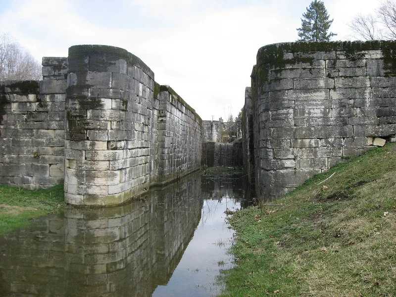
Lockington Locks is a stretch of the Miami and Erie Canal in Shelby and Miami counties, Ohio, covering about 3 3/4 miles of canal right-of-way. Work began in 1833. The district includes seven stone locks, an aqueduct abutment and turning basins. Engineers built a battery of six locks to lift boats 67 feet to the plateau at Lockington. The locks were made of cut freestone, many blocks over 500 pounds, hauled by ox team from Dayton. The nomination describes the site as the largest and most striking concentration of original canal features in Ohio and one of the costliest engineering efforts in the state's canal network. The canal segment carried traffic from 1845 to 1877, and local traffic continued until 1899, when the aqueduct broke under a stone-hauling boat. The locks decayed after 1900 until cleanup in the 1950s. The Ohio Historical Society took custody in 1966 and now maintains markers, light park facilities and a restored canal section.
Significance in brief: The nomination calls it the greatest single and most spectacular concentration of original canal features in Ohio. The locks were among the most expensive and daring engineering feats of the state's 1000-mile canal system. Six locks are visible from a single vantage point.
Machine-generated summary. This summary was generated by a language model from the official nomination document and has not been reviewed line by line by an editor. It may contain errors. Check the source document before relying on any detail. Source: nomination document (PDF) · National Archives catalog entry. NRHP reference 69000147, listed December 17, 1969. Summary generated October 2026 (model claude-sonnet-5-5, prompt v1.0-2026-10-29, confidence medium).
Key facts
| Address | Miami Canal between Lockington and Washington Twshp., Lockington |
|---|---|
| County | Miami County |
| Listed | December 17, 1969 |
| Reference number | 69000147 |
| Resource type | District |
| Period of significance | 1833-1845 |
| Areas of significance | Commerce, Engineering, Transportation |
| Level of significance | State |
| Status (as stated in the nomination) | Condition rated fair; gates and hardware have deteriorated or disappeared. Public park with markers; a 1.25-mile segment is being restored by the Ohio Historical Society, with a reproduction canal boat to operate in 1970. |
| Acreage | 45 |
| Coordinates | 40.19496, -84.24326 (NPS GIS) |
What listing means for this property
This is a historic district. Buildings within its boundary are either contributing (they add to the district's significance) or non-contributing. Owners of contributing income-producing buildings can claim the 20% federal rehabilitation tax credit; homeowners should look at state credits. National Register districts impose no design review by themselves; a local historic district ordinance, if one exists, does (the difference explained).
General information, not legal or tax advice. Rules change; confirm with your State Historic Preservation Office or a qualified adviser.
Sources and further reading
- National Park Service, National Register of Historic Places database (snapshot May 2026), reference 69000147.
- Nomination form (PDF, National Archives) — catalog entry
- Wikipedia article (used for cross-checking only; text not reproduced here)
- Wikidata Q282889
- This listing as JSON
Last updated October 2026. Found an error? See the editorial policy for how to report it.