Mount Auburn Historic District
Also known as: See Also:William Howard Taft National Historic Site; Samuel H

Why it's listed
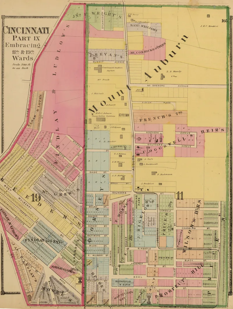
Mt. Auburn is a hillside neighborhood of Cincinnati whose Auburn Avenue once earned the nickname "Fifth Avenue" of the city. Settlement began about 1819 with the home of James Key, and the area was known as Key's Hill until about 1837. Prominent residents built large Italianate houses, many with square towers, along the avenue. Examples include the Henry Martin House, the Thomas Phillips House, Sunnyside (the William Doane home) and the Mordecai White House. Also present are Second Empire, Greek Revival and Gothic Revival buildings, along with Methodist, Baptist and Presbyterian churches. The district takes in about 41.4 acres and three parks: Hopkins, Jackson Hill and Inwood. Former residents included bankers, industrialists, jurists, a governor and a conductor. Some older houses have been lost to hospital-related construction, but many survive and show the status and ambitions of the early settlers. The picturesque views and closeness to downtown that first drew residents remain.
Significance in brief: The district was a residential area for Cincinnati's civic, business, cultural and religious leaders from about 1819. Its large homes, many with towers, show the wealth and social aspirations of early settlers and keep the visual character of the 19th-century neighborhood. Auburn Avenue was once called the "Fifth Avenue" of Cincinnati.
Machine-generated summary. This summary was generated by a language model from the official nomination document and has not been reviewed line by line by an editor. It may contain errors. Check the source document before relying on any detail. Source: nomination document (PDF) · National Archives catalog entry. NRHP reference 73001464, listed March 28, 1973. Summary generated October 2026 (model claude-sonnet-5-5, prompt v1.0-2026-10-29, confidence medium).
Key facts
| Address | Both sides of Auburn Ave. from Ringgold St. to Howard Taft Rd., Cincinnati |
|---|---|
| County | Hamilton County |
| Listed | March 28, 1973 |
| Reference number | 73001464 |
| Resource type | District |
| Period of significance | 1819-1900 |
| Architect / builder | H.E. Siter (Mt. Auburn Presbyterian Church); Samuel Hannaford (remodeled the Henry Powell Residence in 1886) |
| Architectural style | Predominantly Italianate, with Gothic Revival, Second Empire, Greek Revival, Italian Villa, Romanesque-Gothic Revival and neo-Georgian examples |
| Areas of significance | Politics/Government, Architecture, Social History |
| Level of significance | Local |
| Status (as stated in the nomination) | Condition listed as fair and altered. Many early structures remain in residential use or house social agencies and medical offices. Some older homes were demolished for medical and court buildings. |
| Acreage | 41.4 |
| Coordinates | 39.12384, -84.50756 (NPS GIS) |
What listing means for this property
This is a historic district. Buildings within its boundary are either contributing (they add to the district's significance) or non-contributing. Owners of contributing income-producing buildings can claim the 20% federal rehabilitation tax credit; homeowners should look at state credits. National Register districts impose no design review by themselves; a local historic district ordinance, if one exists, does (the difference explained).
General information, not legal or tax advice. Rules change; confirm with your State Historic Preservation Office or a qualified adviser.
Sources and further reading
- National Park Service, National Register of Historic Places database (snapshot May 2026), reference 73001464.
- Nomination form (PDF, National Archives) — catalog entry
- Wikipedia article (used for cross-checking only; text not reproduced here)
- Wikidata Q6919525
- This listing as JSON
Last updated October 2026. Found an error? See the editorial policy for how to report it.