Laurel Homes Historic District

Why it's listed
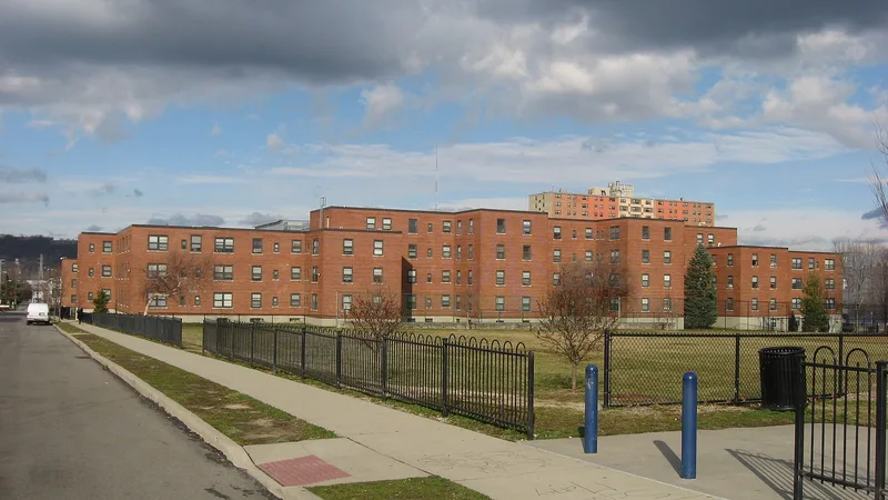
Laurel Homes is a 1930s public housing complex in Cincinnati's West End, built 1936-1938 with Public Works Administration funding on cleared slum land. It holds 1,303 apartments in 25 three- and four-story brick buildings, arranged around courtyards, vistas and axes. Four smaller brick buildings accompany them: two long, low store buildings on Linn Street, a heating plant and a playground building. Two city-owned green spaces, Laurel Park and Laurel Playground, are part of the district. Building coverage dropped from 65 percent of the land in the old slum to 20 percent. The complex ranks as the second largest PWA housing project nationally, after Williamsburg Houses in Brooklyn, and was the first and largest public housing project in Cincinnati. It is valued for showing Depression-era planning ideas such as standardization, low density, communal space and attention to light and air, and for its role in local humanitarian and political efforts. Original windows were replaced in 1985, but the complex remains largely intact.
Significance in brief: The nomination calls it the second largest PWA public housing project in the country and the first and largest local one. It illustrates 1930s housing and planning ideas and marks a milestone in local efforts to improve living conditions for the poor. It also reflects cooperation among the city's political bodies, agencies and civic groups, and debates over racial access to housing.
Machine-generated summary. This summary was generated by a language model from the official nomination document and has not been reviewed line by line by an editor. It may contain errors. Check the source document before relying on any detail. Source: nomination document (PDF) · National Archives catalog entry. NRHP reference 87000690, listed May 19, 1987. Summary generated October 2026 (model claude-sonnet-5-5, prompt v1.0-2026-10-29, confidence high).
Key facts
| Address | Roughly bounded by Liberty and John Sts., Ezzard Charles Dr., and Linn St., Cincinnati |
|---|---|
| County | Hamilton County |
| Listed | May 19, 1987 |
| Reference number | 87000690 |
| Resource type | District |
| Period of significance | ca. 1933-1938 |
| Architect / builder | Associated Architects (listed below) |
| Criteria |
|
| Areas of significance | Community Planning and Development, Politics/Government, Architecture, Social History |
| Level of significance | State |
| Status (as stated in the nomination) | Occupied; described as well preserved and in good condition, with windows replaced in 1985. |
| Acreage | 34 |
| Coordinates | 39.11132, -84.52429 (NPS GIS) |
What listing means for this property
This is a historic district. Buildings within its boundary are either contributing (they add to the district's significance) or non-contributing. Owners of contributing income-producing buildings can claim the 20% federal rehabilitation tax credit; homeowners should look at state credits. National Register districts impose no design review by themselves; a local historic district ordinance, if one exists, does (the difference explained).
General information, not legal or tax advice. Rules change; confirm with your State Historic Preservation Office or a qualified adviser.
Sources and further reading
- National Park Service, National Register of Historic Places database (snapshot May 2026), reference 87000690.
- Nomination form (PDF, National Archives) — catalog entry
- Wikipedia article (used for cross-checking only; text not reproduced here)
- Wikidata Q14716595
- This listing as JSON
Last updated October 2026. Found an error? See the editorial policy for how to report it.