Old White Church Cemetery
Also known as: Emanuel Church Cemetery

Why it's listed
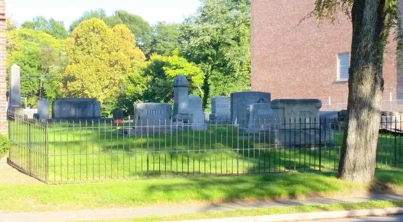
Old White Church Cemetery is the oldest burying ground in Lincolnton, North Carolina. In 1788 the town's Lutheran and Reformed congregations acquired a tract of just over two acres for a union church, schools and burials. The log church, later whitewashed and known as the Old White Church, burned in 1893. The cemetery is now a plain, grass-covered rectangle with about 265 marked graves, the earliest dated 1801. It holds a large group of antebellum box tombs, two marble obelisks, and the John Hoke Family Tomb, a burial vault. Stones show German-influenced designs and the work of regional carvers and marble yards. The tract shrank in 1951, when the south half, long used for African American and other less affluent burials, was sold and 201 graves were moved to the north half. The cemetery was recognized for its early settlement history, its link to Lincolnton's prominent citizens, and its funerary art from about 1801 to 1944.
Significance in brief: It was the only designated burial place in Lincolnton from 1788 until the mid-1820s and holds the graves of many early prominent citizens. It also contains a notable collection of nineteenth-century gravestones by known stone carvers and marble yards, including box tombs, obelisks and the John Hoke Family Tomb.
Machine-generated summary. This summary was generated by a language model from the official nomination document and has not been reviewed line by line by an editor. It may contain errors. Check the source document before relying on any detail. Source: nomination document (PDF) · National Archives catalog entry. NRHP reference 94001459, listed December 14, 1994. Summary generated October 2026 (model claude-sonnet-5-5, prompt v1.0-2026-10-29, confidence medium).
Key facts
| Address | Jct. of S. Aspen and Church Sts., E corner, Lincolnton |
|---|---|
| County | Lincoln County |
| Listed | December 14, 1994 |
| Reference number | 94001459 |
| Resource type | District |
| Period of significance | ca. 1801-1944 |
| Criteria |
|
| Areas of significance | Exploration/Settlement, Other |
| Level of significance | Local |
| Status (as stated in the nomination) | Open grassy cemetery, mowed regularly; about half of the original tract was sold in 1951 and 201 graves were relocated. A metal perimeter fence was begun in 1994. |
| Acreage | 0.9 |
| Coordinates | 35.46980, -81.25551 (NPS GIS) |
What listing means for this property
This is a historic district. Buildings within its boundary are either contributing (they add to the district's significance) or non-contributing. Owners of contributing income-producing buildings can claim the 20% federal rehabilitation tax credit; homeowners should look at state credits. National Register districts impose no design review by themselves; a local historic district ordinance, if one exists, does (the difference explained).
General information, not legal or tax advice. Rules change; confirm with your State Historic Preservation Office or a qualified adviser.
Sources and further reading
- National Park Service, National Register of Historic Places database (snapshot May 2026), reference 94001459.
- Nomination form (PDF, National Archives) — catalog entry
- Wikipedia article (used for cross-checking only; text not reproduced here)
- Wikidata Q19987408
- This listing as JSON
Last updated October 2026. Found an error? See the editorial policy for how to report it.