Union Cemetery
Also known as: South Elm Street Cemetery
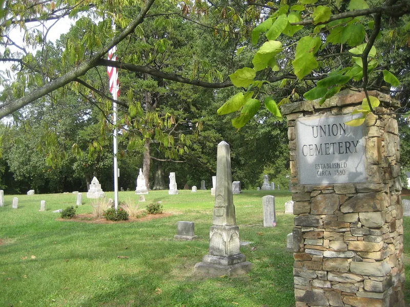

Why it's listed
Union Cemetery is a four-acre burial ground in South Greensboro, North Carolina, established in the early 1880s by the congregations of St. Matthew's Methodist, St. James Presbyterian and Providence Baptist churches as a cemetery for Black residents. Burials continued until 1940, and the stone markers include granite, marble and cast stone forms such as slant markers, steles, obelisks and urns. The cemetery is connected to Warnersville, a settlement founded in 1868 by Quaker Yardley Warner on lots sold to freed slaves. Among those buried here are community leaders such as Harmon Unthank, a bank director, and Dr. James C. Waddy, a physician. The size and craftsmanship of the gravestones are regarded as evidence of the relative prosperity of the Warnersville community and the professional standing of its residents, and the cemetery is one of the few remaining physical links to that community.
Significance in brief: The nomination argues the cemetery is tied to Warnersville, one of North Carolina's earliest planned subdivisions for freedmen, and that many of its early Black leaders are buried there. It also argues the gravemarkers are unusually elaborate and sophisticated for early Black cemeteries in the county, reflecting the community's prosperity.
Machine-generated summary. This summary was generated by a language model from the official nomination document and has not been reviewed line by line by an editor. It may contain errors. Check the source document before relying on any detail. Source: nomination document (PDF) · National Archives catalog entry. NRHP reference 93001142, listed October 21, 1993. Summary generated October 2026 (model claude-haiku-5-5, prompt v1.1-2026-10-29, confidence high).
Key facts
| Address | 900 blook S. Elm St., Greensboro |
|---|---|
| County | Guilford County |
| Listed | October 21, 1993 |
| Reference number | 93001142 |
| Resource type | Site |
| Period of significance | 1882-1940 |
| Criteria |
|
| Areas of significance | Art, Black |
| Level of significance | Local |
| Status (as stated in the nomination) | Most gravemarkers are upright and in good condition, though some are overturned and finials have been lost; the city maintains the grounds minimally. |
| Acreage | 4 |
| Coordinates | 36.05889, -79.79107 (NPS GIS) |
What listing means for this property
Sites (archaeological sites, battlefields, landscapes) are often listed with a restricted address to protect them from looting or disturbance. Listing is honorary for private owners; federal undertakings on or near the site go through Section 106 review, and state laws may protect burials and artefacts regardless of listing.
General information, not legal or tax advice. Rules change; confirm with your State Historic Preservation Office or a qualified adviser.
Sources and further reading
- National Park Service, National Register of Historic Places database (snapshot May 2026), reference 93001142.
- Nomination form (PDF, National Archives) — catalog entry
- Wikipedia article (used for cross-checking only; text not reproduced here)
- Wikidata Q21016287
- This listing as JSON
Last updated October 2026. Found an error? See the editorial policy for how to report it.