Fort Johnston

Why it's listed
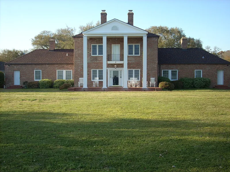
Fort Johnston occupies a site on Moore Street in Southport, North Carolina, overlooking the Cape Fear River. The British established the fort about 1750, and it is described as the first North Carolina fort authorized by the Legislature. Royal Governor Josiah Martin lived there last before Patriots led by Cornelius Harnett and Robert Howe destroyed the early fort in July 1775. The land was ceded to the United States in 1794, and a garrison of artillery troops was in place by 1800. The post was abandoned and reoccupied several times, was taken over by North Carolina militia in 1861, and helped keep Wilmington open to blockade runners during the Civil War. Union forces occupied it in 1865, and it was finally abandoned in 1881. Today the site holds military housing and tennis courts, along with a brick commander's house from about 1800 that was substantially renovated in the 1950s.
Significance in brief: The site is described as the first North Carolina fort authorized by the Legislature and the last residence of Royal Governor Josiah Martin. It served as a garrisoned post through the Revolutionary era, the early United States period and the Civil War, when it helped keep Wilmington open to blockade runners. It was finally abandoned in February 1881.
Machine-generated summary. This summary was generated by a language model from the official nomination document and has not been reviewed line by line by an editor. It may contain errors. Check the source document before relying on any detail. Source: nomination document (PDF) · National Archives catalog entry. NRHP reference 74001327, listed June 7, 1974. Summary generated October 2026 (model claude-sonnet-5-5, prompt v1.0-2026-10-29, confidence medium).
Key facts
| Address | Moore St., Southport |
|---|---|
| County | Brunswick County |
| Listed | June 7, 1974 |
| Reference number | 74001327 |
| Resource type | Site |
| Period of significance | 18th and 19th centuries (specific dates not given) |
| Areas of significance | Military |
| Level of significance | National |
| Status (as stated in the nomination) | Occupied by military housing, tennis courts and the commander's quarters; the original house was renovated in the mid-1950s and is described as altered, in good condition. |
| Acreage | 6 |
| Within district | Southport Historic District |
| Coordinates | 33.91805, -78.01750 (NPS GIS) |
What listing means for this property
Sites (archaeological sites, battlefields, landscapes) are often listed with a restricted address to protect them from looting or disturbance. Listing is honorary for private owners; federal undertakings on or near the site go through Section 106 review, and state laws may protect burials and artefacts regardless of listing.
General information, not legal or tax advice. Rules change; confirm with your State Historic Preservation Office or a qualified adviser.
Sources and further reading
- National Park Service, National Register of Historic Places database (snapshot May 2026), reference 74001327.
- Nomination form (PDF, National Archives) — catalog entry
- Wikipedia article (used for cross-checking only; text not reproduced here)
- Wikidata Q5471415
- This listing as JSON
Last updated October 2026. Found an error? See the editorial policy for how to report it.