Southport Historic District

Why it's listed
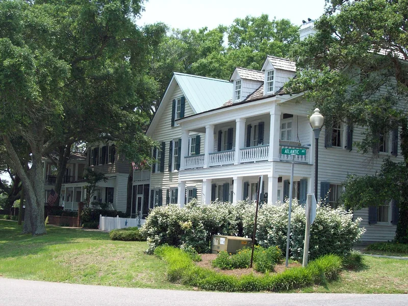
Southport is a small coastal town at the mouth of the Cape Fear River, first laid out in 1792-93 as Smithville. Its livelihood long depended on river piloting, guiding ships past shoals to Wilmington. Most of the district's buildings date from 1885-1905, when a surge of speculation and the opening of local brick and lumber companies led to about a hundred new houses in the years 1889-1896. Local carpenters such as the Daniel brothers and A. J. Robbins built modest one- and two-story frame dwellings using traditional plans like the double cottage and side passage house, rather than copying national styles. Brick commercial buildings on East Moore Street followed in the early twentieth century. Live and water oaks canopy the uncurbed, winding streets, and fishing boats and docks add to the town's character. The district was listed because it offers an unusually complete picture of Victorian building practice in a small North Carolina town.
Significance in brief: The nomination calls Southport the best example of a Victorian coastal town in North Carolina. Its livelihood was tied to river piloting, and its late nineteenth century boom produced a well-documented body of vernacular frame houses and brick commercial buildings. It keeps its meandering uncurbed streets under oak canopies, and over one hundred buildings can be traced to a specific carpenter-builder and year.
Machine-generated summary. This summary was generated by a language model from the official nomination document and has not been reviewed line by line by an editor. It may contain errors. Check the source document before relying on any detail. Source: nomination document (PDF) · National Archives catalog entry. NRHP reference 80002801, listed November 25, 1980. Summary generated October 2026 (model claude-sonnet-5-5, prompt v1.0-2026-10-29, confidence medium).
Key facts
| Address | Roughly bounded by Cape Fear River, Rhett, Bay, Short and Brown Sts., Southport |
|---|---|
| County | Brunswick County |
| Listed | November 25, 1980 |
| Reference number | 80002801 |
| Resource type | District |
| Architect / builder | Local carpenter-builders including A. J. Robbins, Henry and Joseph Daniel, George Davis, and W. T. Ottoway |
| Architectural style | Vernacular Victorian; local building tradition with some Greek Revival, Colonial Revival and bungalow elements |
| Areas of significance | Transportation, Architecture |
| Level of significance | Local |
| Status (as stated in the nomination) | Condition is marked excellent, good, fair, deteriorated and altered; the district includes both occupied and unoccupied properties. Departure of county government in 1978 left numerous buildings empty. |
| Acreage | 112 |
| Coordinates | 33.91281, -78.01803 (NPS GIS) |
What listing means for this property
This is a historic district. Buildings within its boundary are either contributing (they add to the district's significance) or non-contributing. Owners of contributing income-producing buildings can claim the 20% federal rehabilitation tax credit; homeowners should look at state credits. National Register districts impose no design review by themselves; a local historic district ordinance, if one exists, does (the difference explained).
General information, not legal or tax advice. Rules change; confirm with your State Historic Preservation Office or a qualified adviser.
Sources and further reading
- National Park Service, National Register of Historic Places database (snapshot May 2026), reference 80002801.
- Nomination form (PDF, National Archives) — catalog entry
- Wikipedia article (used for cross-checking only; text not reproduced here)
- Wikidata Q18158267
- This listing as JSON
Last updated October 2026. Found an error? See the editorial policy for how to report it.