Erie Canal: Second Genesee Aqueduct
Also known as: The Broad Street Aqueduct and Bridge

Why it's listed
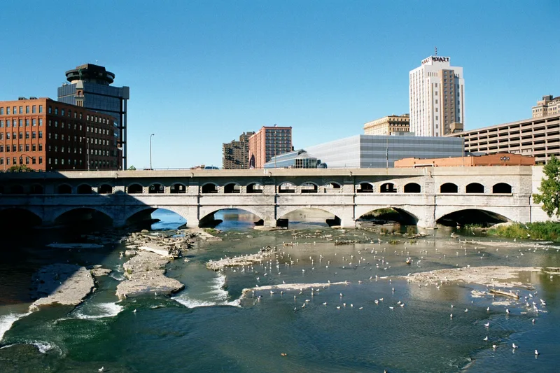
Broad Street crosses the Genesee River in downtown Rochester on a 1927 concrete bridge that sits atop an 1842 stone aqueduct built for the Erie Canal. The aqueduct is 800 feet long and 70 feet wide, with seven arches carried on gray limestone piers and abutments set on bedrock in the river. Its parapets are ten feet thick. Canal engineers Nathan S. Roberts and M.M. Hall planned it after the first, leaky aqueduct proved inadequate, and it cost $445,347. After the canal route was abandoned in 1919, the city bought the right-of-way in 1922. Broad Street was then extended over the aqueduct on a concrete superstructure with a subway below, implemented in 1927. The bridge repeats the piers of the aqueduct but has three small arches for each stone arch. Reinforced in 1973, it still carries traffic. It was listed as the only major Erie Canal aqueduct to survive intact.
Significance in brief: It was one of four major aqueducts of the Erie Canal system and the only one that survives intact. It has served transportation needs for about 130 years, first carrying canal boats and later cars and subway traffic. It combines nineteenth and twentieth century building materials.
Machine-generated summary. This summary was generated by a language model from the official nomination document and has not been reviewed line by line by an editor. It may contain errors. Check the source document before relying on any detail. Source: nomination document (PDF) · National Archives catalog entry. NRHP reference 76001228, listed September 29, 1976. Summary generated October 2026 (model claude-sonnet-5-5, prompt v1.0-2026-10-29, confidence high).
Key facts
| Address | Broad St., Rochester |
|---|---|
| County | Monroe County |
| Listed | September 29, 1976 |
| Reference number | 76001228 |
| Resource type | Structure |
| Period of significance | 1800-1899, 1900- (aqueduct 1836-42; bridge 1927) |
| Architect / builder | Nathan Roberts (aqueduct) |
| Areas of significance | Commerce, Engineering, Transportation |
| Level of significance | State |
| Status (as stated in the nomination) | Occupied and in good condition; the 1927 concrete bridge was reinforced in 1973 and carries city automobile traffic. Subway tracks in the aqueduct bed are not in full use, and the northwestern arm of the subway is used for freight only. |
| Acreage | 0.9 |
| Coordinates | 43.15471, -77.60956 (NPS GIS) |
What listing means for this property
National Register listing is honorary: it recognises significance and does not restrict what a private owner may do without federal money or permits. It unlocks the 20% federal rehabilitation tax credit for income-producing buildings, state credits in many states, and Section 106 review when federal agencies are involved. See what listing means in practice.
General information, not legal or tax advice. Rules change; confirm with your State Historic Preservation Office or a qualified adviser.
Sources and further reading
- National Park Service, National Register of Historic Places database (snapshot May 2026), reference 76001228.
- Nomination form (PDF, National Archives) — catalog entry
- Wikipedia article (used for cross-checking only; text not reproduced here)
- Wikidata Q4971954
- This listing as JSON
Last updated October 2026. Found an error? See the editorial policy for how to report it.