Chinatown and Little Italy Historic District

Why it's listed
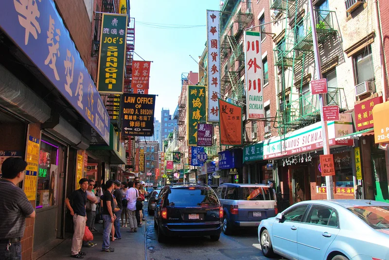
Chinatown and Little Italy together occupy a 38-block area of lower Manhattan where two immigrant communities have overlapped for nearly a century and a half. The streetscape consists mainly of brick tenements five to six stories tall, many with ground-floor shops, cast-iron storefronts and wrought-iron fire escapes. Older Federal and Greek Revival townhouses survive, often altered, along with factories, clubhouses, churches, schools and two parks, Columbus Park and DeSalvio Playground. The district was listed for its role in the history of American immigration, particularly Chinese and Italian settlement during the great wave of arrivals between 1880 and 1921. Its tenements illustrate how housing reform laws, beginning with the Tenement House Act of 1867, shaped urban living. Rear yards and the former Mulberry Bend slum area near Columbus Park may also hold archaeological evidence of daily life. The period of significance runs from about 1800 to 1965.
Significance in brief: The nomination argues the district is nationally significant for the Chinese-American and Italian-American immigrant experience and the broader history of immigration in America (Criterion A). Its tenements reflect the evolution of housing reform laws (Criterion C). Archaeological potential in rear yards and around Columbus Park supports Criterion D.
Machine-generated summary. This summary was generated by a language model from the official nomination document and has not been reviewed line by line by an editor. It may contain errors. Check the source document before relying on any detail. Source: nomination document (PDF) · National Archives catalog entry. NRHP reference 10000012, listed February 12, 2010. Summary generated October 2026 (model claude-sonnet-5-5, prompt v1.0-2026-10-29, confidence medium).
Key facts
| Address | Roughly bounded by Baxter St., Centre St., Cleveland Pl. and Lafayette St. to the W; Jersey St. and E. Houston, New York |
|---|---|
| County | Manhattan |
| Listed | February 12, 2010 |
| Reference number | 10000012 |
| Resource type | District |
| Period of significance | c. 1800 to 1965 |
| Architectural style | Mixed: Federal, Greek Revival, Italianate, Second Empire, Queen Anne, Romanesque, Renaissance, and Commercial Style |
| Criteria |
|
| Areas of significance | Architecture, Social History, Archeology-Historic Non-Aboriginal, Ethnic Heritage-Asian, Ethnic Heritage-European |
| Level of significance | National |
| Status (as stated in the nomination) | Still in active mixed use, with residential, commercial, religious, educational and park functions continuing today. |
| Acreage | 73.2 |
| Coordinates | 40.72343, -73.99561 (NPS GIS) |
What listing means for this property
This is a historic district. Buildings within its boundary are either contributing (they add to the district's significance) or non-contributing. Owners of contributing income-producing buildings can claim the 20% federal rehabilitation tax credit; homeowners should look at state credits. National Register districts impose no design review by themselves; a local historic district ordinance, if one exists, does (the difference explained).
General information, not legal or tax advice. Rules change; confirm with your State Historic Preservation Office or a qualified adviser.
Sources and further reading
- National Park Service, National Register of Historic Places database (snapshot May 2026), reference 10000012.
- Nomination form (PDF, National Archives) — catalog entry
- Wikidata Q104127764
- This listing as JSON
Last updated October 2026. Found an error? See the editorial policy for how to report it.