Fort Crown Point
Also known as: Fort Amherst; Fort St. Frederic

Why it's listed
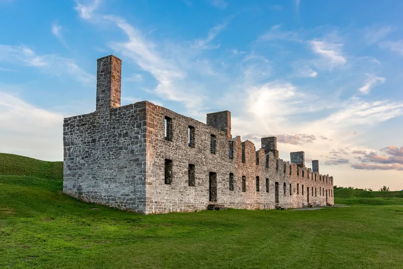
Fort Crown Point is a large ruined British fortress on Lake Champlain in Crown Point, New York. Construction began in 1760, after General Amherst forced the French to give up nearby Fort St. Frederic, which they had built in 1731. The five-sided fort was about three times the size of Fort Ticonderoga and enclosed a 6 1/2-acre parade ground. Its design follows the system of the French engineer Vauban, with a deep dry moat cut from limestone, ramparts 25 feet thick, and five large bastions. A fire and powder magazine explosion in 1773 damaged the fort, and it was never rebuilt. It changed hands during the Revolution, serving as a staging area and supply depot. The ruins of two of three stone barracks survive, and the setting is largely unchanged. New York acquired the land about 1900. It is now a state reservation with a museum and is open to visitors. It was recognized as an outstanding surviving example of 18th-century military engineering.
Significance in brief: The nomination calls the fort, in its ruined but unaltered state, probably the finest surviving architectural and archeological specimen in the United States of 18th-century military engineering. It was built on the system of the French engineer Vauban and later figured in the American Revolution. Together with Fort St. Frederic it forms a major site of the struggle for North America.
Machine-generated summary. This summary was generated by a language model from the official nomination document and has not been reviewed line by line by an editor. It may contain errors. Check the source document before relying on any detail. Source: nomination document (PDF) · National Archives catalog entry. NRHP reference 68000033, listed November 24, 1968. Summary generated October 2026 (model claude-sonnet-5-5, prompt v1.0-2026-10-29, confidence medium).
Key facts
| Address | Crown Point Reservation, SW of Lake Champlain Bridge and NY 8, Crown Point |
|---|---|
| County | Essex County |
| Listed | November 24, 1968 |
| Reference number | 68000033 |
| Resource type | District |
| Architect / builder | Built by British troops under General Sir Jeffery Amherst's command; design based on the fortification system of Marquis de Vauban |
| Architectural style | Colonial military architecture (18th-century fortification) |
| Areas of significance | Historic - Non-Aboriginal, Military, Architecture |
| Level of significance | National |
| National Historic Landmark | Yes, designated November 24, 1968 |
| Status (as stated in the nomination) | Stabilized ruins in excellent condition, administered as the Crown Point State Reservation with a museum, open to visitors. |
| Acreage | 1180 |
| Coordinates | 44.02303, -73.43120 (NPS GIS) |
What listing means for this property
This is a historic district. Buildings within its boundary are either contributing (they add to the district's significance) or non-contributing. Owners of contributing income-producing buildings can claim the 20% federal rehabilitation tax credit; homeowners should look at state credits. National Register districts impose no design review by themselves; a local historic district ordinance, if one exists, does (the difference explained).
General information, not legal or tax advice. Rules change; confirm with your State Historic Preservation Office or a qualified adviser.
Sources and further reading
- National Park Service, National Register of Historic Places database (snapshot May 2026), reference 68000033.
- Nomination form (PDF, National Archives) — catalog entry
- Wikipedia article (used for cross-checking only; text not reproduced here)
- Wikidata Q1438494
- This listing as JSON
Last updated October 2026. Found an error? See the editorial policy for how to report it.