Stuyvesant Heights Historic District (Boundary Increase)

Why it's listed
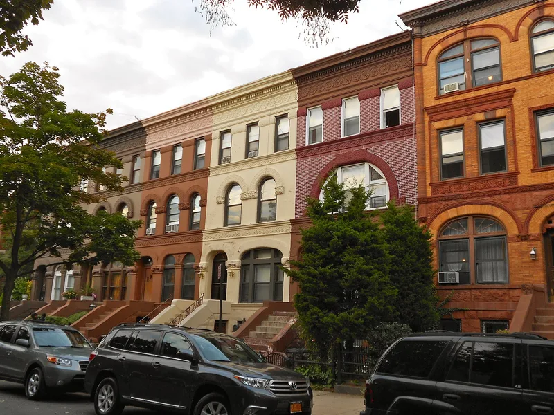
This addition to the Stuyvesant Heights Historic District in central Brooklyn takes in parts of seven blocks along Decatur Street and neighboring streets, directly south of the district listed in 1975. It holds 151 contributing buildings, three noncontributing buildings and one vacant lot. Most are two- and three-story rowhouses with raised basements and high stoops, built mainly between 1884 and the early 1890s. Neo-Grec brownstone and brick fronts predominate, alongside Queen Anne, Romanesque Revival and Neo-Renaissance designs. Seventeen modest multiple dwellings and one church also appear. Several rows have unusually wide cornices incorporating attic windows, a feature found in significant numbers only in central Brooklyn. The earliest buildings date to 1882 and the latest is a 1926 apartment house. The form argues that the area shares architects, developers, styles and residents with the original district, and that its buildings record the shift from farmland to a built-up neighborhood of the city of Brooklyn. The expansion was recognized for architecture and for community planning and development.
Significance in brief: The expansion is argued to share the same historical development, architects, builders, styles and residents as the original district, completing the possible expansion to the south. It contains architecturally distinguished late nineteenth-century residential design, including Neo-Grec, Queen Anne, Romanesque Revival and Neo-Renaissance buildings. It also illustrates the change of the area from rural farmland to an urbanized part of the city of Brooklyn.
Machine-generated summary. This summary was generated by a language model from the official nomination document and has not been reviewed line by line by an editor. It may contain errors. Check the source document before relying on any detail. Source: nomination document (PDF) · National Archives catalog entry. NRHP reference 96001355, listed November 15, 1996. Summary generated October 2026 (model claude-sonnet-5-5, prompt v1.0-2026-10-29, confidence high).
Key facts
| Address | Roughly, Decatur St. from Tompkins to Lewis Aves., Brooklyn |
|---|---|
| County | Brooklyn |
| Listed | November 15, 1996 |
| Reference number | 96001355 |
| Resource type | District |
| Period of significance | c. 1882-1926 |
| Architect / builder | various |
| Architectural style | Late Victorian: Italianate, Second Empire, Neo-Grec, Queen Anne, Romanesque Revival, Renaissance |
| Criteria |
|
| Areas of significance | Architecture, Community Planning and Development |
| Level of significance | Local |
| Status (as stated in the nomination) | The buildings remain in residential use as single and multiple dwellings; some have lost cornices, stoops or other original details, and one site is a vacant lot. |
| Acreage | 10 |
| Within district | Stuyvesant Heights Historic District |
| Coordinates | 40.68052, -73.94103 (NPS GIS) |
What listing means for this property
This is a historic district. Buildings within its boundary are either contributing (they add to the district's significance) or non-contributing. Owners of contributing income-producing buildings can claim the 20% federal rehabilitation tax credit; homeowners should look at state credits. National Register districts impose no design review by themselves; a local historic district ordinance, if one exists, does (the difference explained).
General information, not legal or tax advice. Rules change; confirm with your State Historic Preservation Office or a qualified adviser.
Sources and further reading
- National Park Service, National Register of Historic Places database (snapshot May 2026), reference 96001355.
- Nomination form (PDF, National Archives) — catalog entry
- Wikidata Q7629271
- This listing as JSON
Last updated October 2026. Found an error? See the editorial policy for how to report it.