Stuyvesant Heights Historic District

Why it's listed
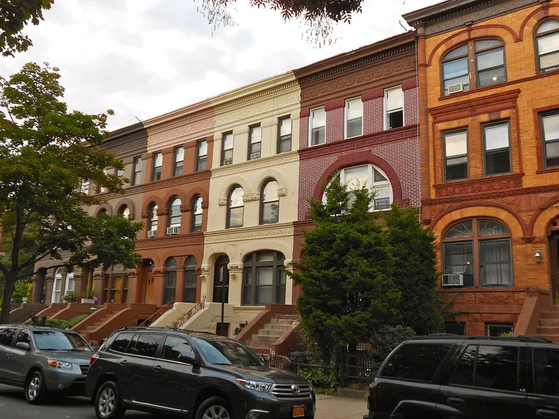
Stuyvesant Heights is a Brooklyn neighborhood of about 430 buildings on thirteen blocks north of Fulton Street, built up mostly between 1870 and 1920. Tree-shaded streets and broad avenues are lined with two- and three-story row houses, many behind planted front yards, along with some free-standing suburban-style houses, early four-story apartment houses, churches and a few small stores. The rows show changing tastes over five decades: late Italianate brownstones on MacDonough Street, neo-Grec details, Romanesque Revival and Queen Anne groups, limestone neo-classical houses on Stuyvesant Avenue, and neo-Georgian and Spanish Renaissance houses on Bainbridge Street. Churches include Mount Lebanon Baptist and Our Lady of Victory. The area was once farmland near the hamlet of Bedford. Early residents were mostly middle-class merchants and professionals of German, Irish and English descent. From the 1930s it became part of a predominantly Black community with many owner-occupied homes. The district was listed for its harmonious character and architectural quality.
Significance in brief: The district is described as an unusually fine 19th and early 20th century residential area with tree-lined streets and rows of architecturally notable houses at low, uniform heights. Its buildings reflect successive architectural styles, from Italianate to Spanish Renaissance, as interpreted by local Brooklyn builders and architects. It also includes churches of architectural distinction and early apartment houses, and is called one of Brooklyn's outstanding neighborhoods.
Machine-generated summary. This summary was generated by a language model from the official nomination document and has not been reviewed line by line by an editor. It may contain errors. Check the source document before relying on any detail. Source: nomination document (PDF) · National Archives catalog entry. NRHP reference 75001193, listed December 4, 1975. Summary generated October 2026 (model claude-sonnet-5-5, prompt v1.0-2026-10-29, confidence high).
Key facts
| Address | Roughly bounded by Macon, Tompkins, Decatur, Lewis, Chauncey, and Stuyvesant, New York |
|---|---|
| County | Brooklyn |
| Listed | December 4, 1975 |
| Reference number | 75001193 |
| Resource type | District |
| Period of significance | 1870-1920 |
| Architectural style | Italianate, French Second Empire, neo-Grec, Romanesque Revival, Queen Anne, neo-classical, neo-Georgian and Spanish Renaissance |
| Areas of significance | Architecture |
| Level of significance | Local |
| Status (as stated in the nomination) | Described as a stable, well-kept residential neighborhood in good condition, with occupied buildings, mostly private residences along with some religious and commercial uses. |
| Acreage | 42 |
| Within district | Stuyvesant Heights Historic District (Boundary Increase) |
| Coordinates | 40.68118, -73.93688 (NPS GIS) |
What listing means for this property
This is a historic district. Buildings within its boundary are either contributing (they add to the district's significance) or non-contributing. Owners of contributing income-producing buildings can claim the 20% federal rehabilitation tax credit; homeowners should look at state credits. National Register districts impose no design review by themselves; a local historic district ordinance, if one exists, does (the difference explained).
General information, not legal or tax advice. Rules change; confirm with your State Historic Preservation Office or a qualified adviser.
Sources and further reading
- National Park Service, National Register of Historic Places database (snapshot May 2026), reference 75001193.
- Nomination form (PDF, National Archives) — catalog entry
- Wikidata Q7629271
- This listing as JSON
Last updated October 2026. Found an error? See the editorial policy for how to report it.