Ocean Parkway

Why it's listed
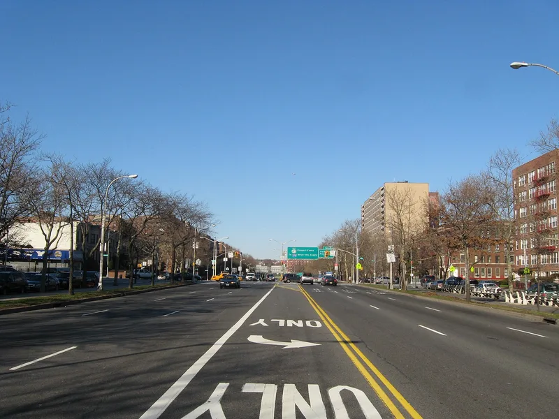
Ocean Parkway is a six-mile boulevard in Brooklyn between Church Avenue and Seabreeze Avenue, planned in 1866 by Frederick Law Olmsted and Calvert Vaux to connect Prospect Park with Coney Island. Built in 1874-76, it is 210 feet wide, with a 70-foot central drive, two 20-foot tree-lined malls, 25-foot service roads and 15-foot sidewalks. The western mall holds a promenade, benches and a bicycle path, while the eastern mall originally carried a bridle path. It is recognized as the first parkway planned in the United States. Olmsted drew on European examples, including the Paris boulevard leading to the Bois de Boulogne and Berlin's Unter den Linden, and coined the term parkway for this type of road. Property owners along the route bore the original construction cost. Although paving has changed and the Prospect Expressway now meets it, the divided plan and its role as a promenade and greenbelt for neighbouring communities remain.
Significance in brief: The nomination argues Ocean Parkway is architecturally and historically significant as the first parkway planned in the United States, establishing a new concept in road construction. It combined tree-lined malls, walkways, pleasure drives and service roads, and was meant to link Prospect Park with Coney Island. It is also where Olmsted first worked out his ideas for a parkway system.
Machine-generated summary. This summary was generated by a language model from the official nomination document and has not been reviewed line by line by an editor. It may contain errors. Check the source document before relying on any detail. Source: nomination document (PDF) · National Archives catalog entry. NRHP reference 83001697, listed September 8, 1983. Summary generated October 2026 (model claude-sonnet-5-5, prompt v1.0-2026-10-29, confidence high).
Key facts
| Address | From Church Ave. to Seabreeze Ave., New York |
|---|---|
| County | Brooklyn |
| Listed | September 8, 1983 |
| Reference number | 83001697 |
| Resource type | Structure |
| Period of significance | 1866-76 |
| Architect / builder | Frederick Law Olmsted & Calvert Vaux |
| Areas of significance | Community Planning and Development, Landscape Architecture |
| Level of significance | National |
| Status (as stated in the nomination) | Condition is given as fair and altered but on its original site. The roadways and sidewalks are now paved in concrete, yet the divided plan keeps its original length and dimensions. The central roadway can no longer be considered a pleasure drive since the Prospect Expressway merges with it. |
| Acreage | 123 |
| Coordinates | 40.60933, -73.97077 (NPS GIS) |
What listing means for this property
National Register listing is honorary: it recognises significance and does not restrict what a private owner may do without federal money or permits. It unlocks the 20% federal rehabilitation tax credit for income-producing buildings, state credits in many states, and Section 106 review when federal agencies are involved. See what listing means in practice.
General information, not legal or tax advice. Rules change; confirm with your State Historic Preservation Office or a qualified adviser.
Sources and further reading
- National Park Service, National Register of Historic Places database (snapshot May 2026), reference 83001697.
- Nomination form (PDF, National Archives) — catalog entry
- Wikipedia article (used for cross-checking only; text not reproduced here)
- Wikidata Q2487858
- This listing as JSON
Last updated October 2026. Found an error? See the editorial policy for how to report it.